Twenty years ago we went to Crete. Enticed by the write up in brochure in a cafe we decided to walk the Samaria Gorge. The entrance to the Gorge is from Xyloscalo, near the village of Omalos, leads past the old village of Samaria and (sixteen kilometres, that’s ten miles in old money) later eventually ends at Agia Rouméli, a small pretty coastal village with glorious views of the Mediterranean Sea. And tavernas under canopies of eucalyptus and cypress trees. I have to say it was the thought of this last description that persuaded me.
Last week, much to his excitement, husband (the photographer) found some of his photographs taken with one of his old cameras. These reminded me that this was the very first long walk that we actually did together.
Shades of things to come!
When I say “together” I actually mean that, if I didn’t keep an eye on what he was doing, I’d often be walking for ages before realising I’d been talking to myself and he was nowhere in sight. Since then I’ve learned to take a notebook and pen on these excursions so I can sit and write while he takes dozens of different photographs of the same scene, but from different angles, with different lenses, and all that technical stuff.
Armed with strong hiking boots, sunhats, sun cream, bottles of water and snacks we caught the bus at Chania to take us to Xiloskalo at five in the morning. By the end of the hike I was glad we’d started so early; it was sweltering. But I must admit that, at first, I wasn’t quite as enthusiastic as the photographer to be getting up at that time on holiday.
How wrong I was. This is one hike I will never forget.
Declared a National Park in 1962, mainly to protect the endangered Cretan goats (Kri-Kri) which live in the area, the gorge has a rich history dating back to ancient times. Inhabited by people who worshipped the goddess Samaria. It also served as a refuge for Cretan rebels and freedom fighters during various periods of oppression and occupation by foreign powers such as the Turks, the Germans, and the British.
It also is home to the most exquisite plant life…
The Cretan ebony is found only in Crete, with purple flowers that adorn the Cretan mountains. Other endemic Cretan plant species are the Cretan crocus, the beautiful Cretan bell several aromatic herbs that thrive on the island. ( N.B. This is not one of husband’s photographs but courtesy of CRETA MARIS.I couldn’t resist showing this gorgeous plant, which wasn’t flowering at the time we went – otherwise you would definitely be seeing various angles and shots of it courtesy of husband)
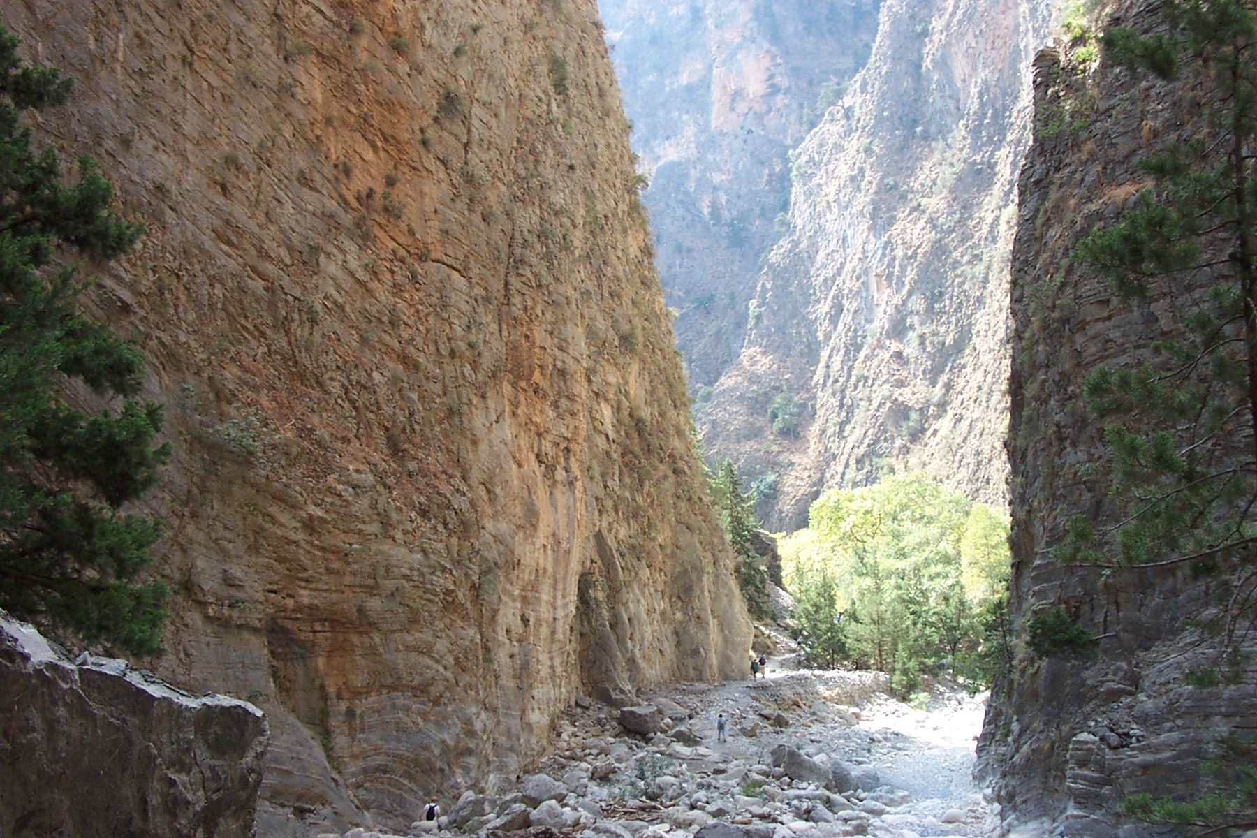
The above is the narrowest and most famous section of the gorge – called Portes or The Iron Gates. It’s thirteen foot wide and one thousand six hundred and forty foot high. This was the most rocky part to walk – though as far as I remember we did much clambering over and around boulders all the way.I was very glad of the stout boots.
It took us six hours before we reached Agia Roumeli and relaxed outside a taverna with a cold glass of water and a dakos ( a hard barley rusk soaked in olive oil with coriander seeds, chopped tomatoes, oregano and cheese). I asked how this was made but I’ve never quite managed to achieve that special flavour we tasted that day)
The gorge is only open from May to October; in the first and last few weeks of that period it may close if there’s a danger of flash floods.
And I was glad that I wasn’t told before we set off that the gorge is home tofour different snakes, the Balkan whip snake, the dice snake, the cat snake and the leopard snake. Although not dangerous I’m relieved i didn’t see one.
Now husband has discovered photographs from his old camera I’m hoping he can find more from other walks we’ve done over the years. They’ve brought back many memories.
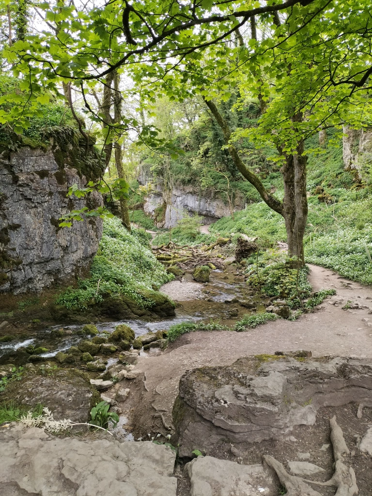
Our last walk in the Yorkshire Dales was a short early evening stroll to a small waterfall called Janet’s Foss, just outside Malham. The name for the waterfall apparently comes from an old folktale that a fairy queen, Janet (sometimes Jennet), lives in a cave at the rear of the fall. There are numerous stories about this: usually wraiths are not thought to be ghosts or demons, but rather a strange entity somewhere in between the two, similar to poltergeists but much more powerful when appearing as a full-bodied apparition. With Janet, there are claims that she would have practised black magic in life and this eternal damnation is her punishment. So, from the numerous conflicting tales we were told when we asked, she was either a magical fairy, or a vengeful creature.
The waterfall carries Gordale Beck over a limestone outcrop into a deep pool below. The pool was traditionally used for sheep dipping, which drew in local villagers as a social occasion. We were told that there have also been a few wedding ceremonies there.Our resident font of all knowledge in the local pub told us that the pool is occasionally used by all-weather wild swimmers. When I mentioned this to the photographer he announced he hadn’t brought his swimming trunks. Not sure he had the right idea about ‘wild swimming’.
Image courtesy of Annabelle Bradley
The footpath from Malham starts from Malham Smithy, where the female blacksmith, Annabelle Bradley, runs blacksmith experience days, and also designs and hand forges sculptural and functional wrought ironwork. We’d stopped to watch her work from outside the door, earlier in the week. It was fascinating. Just leaving the link here, just in case you’re interested: https://www.malhamsmithyonline.co.uk/
Walking over a short bridge and alongside a small beck we went through fields and kissing gates. (No stiles!!)
On the footpath to Janet’s Foss a couple of old tree stumps have become home to hundreds of pennies where people have left them and made a wish to Janet.
We could smell the garlic even before we entered the wood.
Here I go again … can anyone else see the profile of a face in these rocks?
We stayed listening to the rhythmic flow of the water, and waiting for the mysterious green mist that was supposed to sometimes rise from the water- until the chattering and clattering of boots announced the arrival of walkers, and brought us back to reality.
Time to make our way back to the cottage we were staying in. Time to pack for our return home the following morning. Time for just one more glass of wine.
Remember me saying in the last post about our visit toCatrigg Force – a small but impressive waterfall just east of the village of Stainforth? And that the first time we found it we’d actually planned to call to see it as the first part of a massively, more strenuous, longer walk – a longer walk, planned by the photographer? One where we could take in the landscape from the Victoria Cave in Ribblesdale? And I said, more to come on that another time? Well, this is it. The above is the last (nearly last) part of the track up to the cave
Another of my photographs when I stopped to take a breath on the path (path?!!) on the way up to the cave.The photographer was already there. Give him his due, he did come back to help me to the top.
And here it it, the limestone Victoria Cave, located east of Langcliffe in Ribblesdale and discovered by chance in 1837, the year of Queen Victoria’s coronation.
Until then the cave was unknown. Tinsmith Michael Horner (1813-1878) struggled through a small hole between rocks,searching for his dog and found the cave. Inside tound bones, coins and various metal objects on the sediment floor. Later, on the 28th June 1838, Joseph Jackson, a keen amateur archaeologist, investigated further. The Victorians were fascinated by ‘bone caves’ where there might be a possibility of finding evidence for the earliest humans and extinct animals. Some animal bones were actually found here. It’s thought that hyenas used the cave as a den and dragged bones that had been scavenged into it, including hippos, narrow-nosed rhino, elephants and spotted hyenas bones. After the last Ice Age the cave was used by hibernating brown bears. In amongst the animal bones of reindeer was an 11,000 year old antler harpoon point, the first evidence for people in the Yorkshire Dales.Some items from the cave are held at the Craven Museum in Skipton.
The roof of the cave has become increasingly unstable over the years and roof falls are possible.We didn’t go in!
This is another one of my photos (yes I do know it’s less inspiring than the photographer’s). But I spotted this from up high, from outside the cave – and thought it was a large teddy bear, or the skeleton of a teddy bear!! Of course, when we got closer… it was just a pile of rocks. Note to self – contact optician
Just before we set off on the downward trail, and with an eye on the clouds bubbling up in the distance, a photograph of the next five miles we needed to go.
And it’s here I will reveal a moment of a basic and elementary photographer’s mistake.
” One last photo before the rain sets in,” he says, scanning the vista. “I didn’t realise it had become so dark so quickly.”
I waited, didn’t say a word while he huffed and puffed, and glared at the sky. For quite a while Then I stated the obvious. ” Your lens cap is still on.”
Good job he has a brilliant sense of humour!!
We followed the trail past the rugged terrain of the Warrendale Knotts before descending the hillside on the way back to Settle.
Where we had a well- earned cup of tea and a scone.
This was a walk we did twice when we were in the Yorkshire Dales. The second time we were here was by accident. We got lost – surprise, surprise – and came over a hill to find us again at …
Catrigg Force … a small but impressive waterfall just east of the village of Stainforth. The first time we found it we’d actually planned to call to see it as the first part of a longer walk (more to come on that another time!)
After a snack in the local pub (called the The Craven Heifer in Stainforth – spot a theme in these posts?!!) we headed up a bridleway called Goat Lane. (not sure why it’s called that, we only saw sheep and lambs – definitely no cows… well not at this point anyway!). The track, between parallel stone walls, is a small section of the Pennine Bridleway
We meandered along the upward track for about a mile, past several derelict farm buildings, and stopping to admire the view. In the distance on the moorland, are the Winskill Stones, pedestals of limestone and topped with slate, left behind by ice-age glaciers.Finally we reached the signpost for Catrigg Foss on the left of the track.
No stile this time, a kissing gate, leading to a steep, rocky, narrow, path, down to the stream, Catrigg Beck, which flows from the hills and feeds the waterfall.
The poor quality and lack of any particular viewpoint/perspective in this photograph is because it was taken by me, on my mobile phone, while balancing on the edge of the waterfall and hanging onto a branch of a nearby tree. All without the knowledge of the photographer, who’d wandered off to find the the base of the waterfall.
I followed. Leaving the stream, I made my way down another narrow path alongside a sheer wall of limestone rock and a tree-lined drop to a deep, hidden gully that holds the waterfall and the shallow river, the continuation of Catrigg Beck. There were two separate, quite magical falls, well over six metres in height in the long wooded copse. The sprays of water, a sparkling shower of colours in the sunshine that flickered through the leaves, landed all around us. The only sounds were the waterfalls and the calls of birds. Perfect peace …
Ah well… as I said, this was only the start of a massively, more strenuous, longer walk – a longer walk, planned by the photographer, to take in the landscape from the Victoria Cave in Ribblesdale (discovered by chance in 1837, the year of Queen Victoria’s coronation). This second time we were here was purely by coincidence, and at the end of a quite sedate walk … for us! We ambled through fields, back to where we were staying in a tiny cottage in Langcliffe.
By the way…
Apparently Catrigg Force was a favourite haunt of composer Edward Elgar. He visited the waterfalls and, during his visits to the Yorkshire Dales, was inspired to compose Pomp and Circumstance and the Enigma Variations, his most famous works.
Three fun facts about Elgar – Not only was he a composer, but he was also an amateur chemist. In his spare time, he would tinker with experiments. He was the first composer to fully embrace recording music. And he loved cycling. He had a Royal Sunbeam bicycle that he nicknamed ‘Mr. Phoebus. ‘