

Our first walk: an easy five mile circular walk. We thought…
We followed a footpath alongside a stream and through a field covered in glorious wildflowers, including one that we later discovered was called the Deptford pink which is nationally rare. I took a photo of the flower: it had a long and deep pink petals with pale spots and ragged edges. Unfortunately, later (not having the expertise of the photgrapher), I saw that I’d had my mobile phone turned the wrong way round and had an image of a red, sweaty face … mine (well it was a hot day).

So here is a photo of the Deptford pink courtesy of The Species Recovery Trust. Apparently the plant has been used in traditional medicine for various purposes, such as treating digestive ailments and as a diuretic.
This area is called Coed y Felin and includeds an ancient oak/ash woodland planted with sycamore, beech and sweet chestnut.

Pathways criss-cross this ancient woodland site, leaving clues to its long-held links with the local population. Its timber has been used to support local mining villages for centuries. But Llanrwst has also long been known as a market town with a history of a whole range of industries over the centuries, one of which is a thriving woollen industry. Apparently it’s historically recorded that in the Middle Ages the price for wool at Llanrwst market set the price for wool throughout England and Wales in that period.The photographs below are the ruins of a woollen mill, Felin Uchaf.


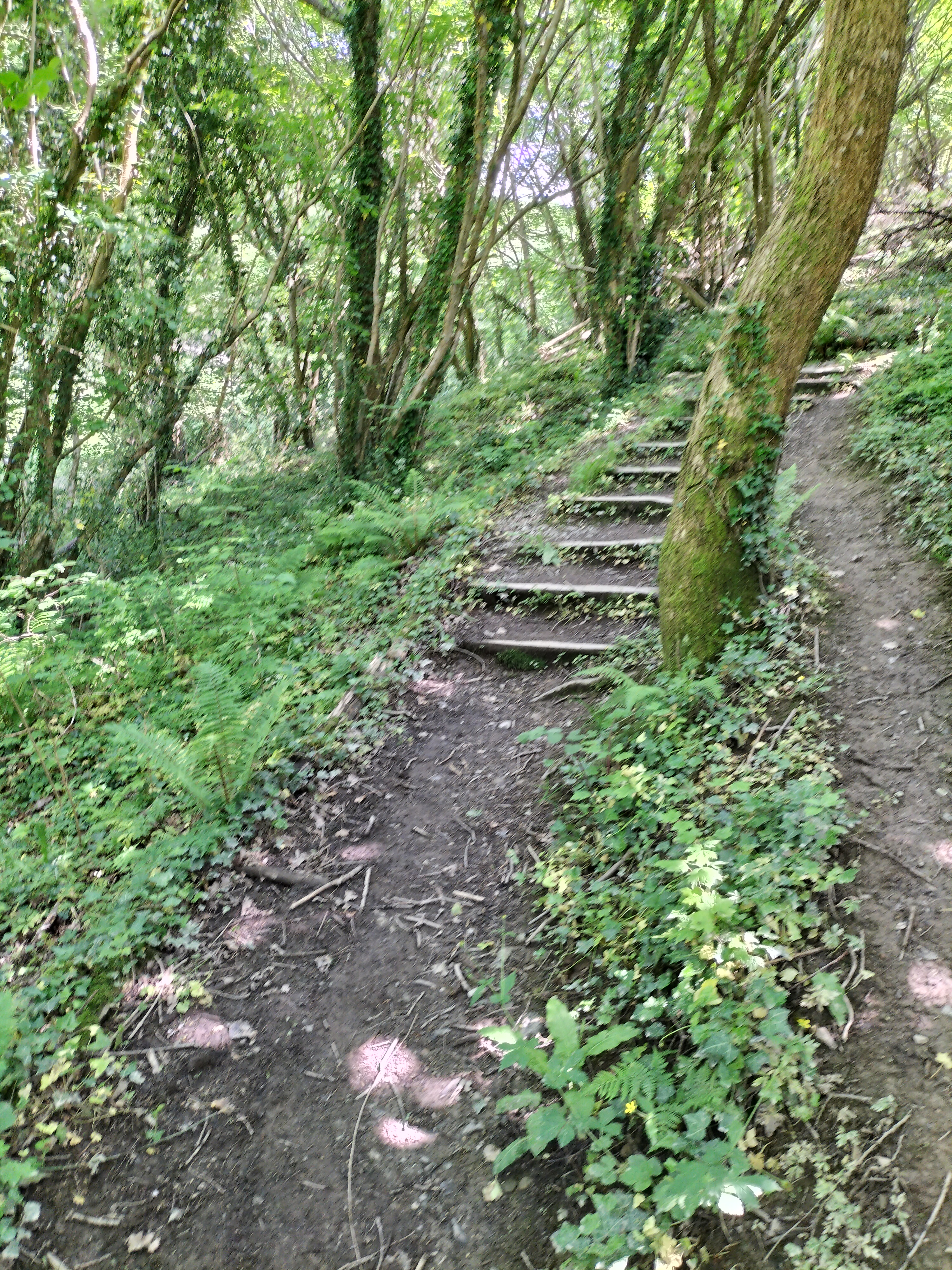
The directions told us to zig zag up a steep lane.


And then continue for about one and a half mile along a lane. Or rather, up a very steep lane!


And this is where the five mile circular walk became … a little longer. The signs disappeared. And there were four turn-offs to choose from. So, three times, we wandered up this lane, (which I swear was at least half a mile long from bottom to top) and then down and then up again.
Until I stopped for breath and the photographer declared joyfully, ‘There’s a lovely view from up here.’

After that I believe the person who wrote the directions became bored, jotted down a few notes about going through fields, and went home. And we more or less followed our noses. Or, should I say, because anyone who knows me knows I have no sense of direction whatsoever, I followed the photographer (who, true to form, was really only looking for “great shots”)
We meandered through fields along vague paths, which I was sure were sheep trails … see the evidence below?

And note … a stile! After last year’s walks in the Yorkshire Dales here and here, the photographer promised no stiles this time. And yet, on the very first walk – a stile.
It was quite a quiet walk back to the start after that…
PS: The following is an interesting article about Y Pont Fawr – the bridge in Llanrwst that, on our way to the cottage we were staying at, we tried to cross three times before being successful. Because of the high crown of the bridge it’s impossible to see if there’s another vehicle coming the opposite way … until it’s almost too late.
As this piece says further down: “The bridge is too narrow for vehicles to pass on it, and its hump limits forward visibility. This explains the local nickname Pont y Rhegi – “bridge of swearing”.” I’m not saying who added to this nickname, but the photographer refused my request to stop to take a photograph of the bridge.
Pont Fawr, Llanrwst
A ford crossed the river Conwy in this vicinity long before it was bridged. The original bridge was declared unsafe in 1626 and preparations began for its replacement, funded by the people of Caernarfonshire (west of the river) and Denbighshire (east of the river). In 1634 four Lancashire stonemasons were contracted to build the new bridge. The year 1636 and the royal coat of arms are shown on a plaque on the upstream side of the bridge, which is known as Pont Fawr (“large bridge”).
The workmen who built the bridge inserted the keystones for the central arch upside down. This was not discovered until the opening day, when the arch collapsed! The central arch rises to c.18 metres above the water.
The renowned architect Inigo Jones was professionally associated with the wealthy Wynn family of Llanrwst, and legend has it that he designed Pont Fawr. The pictures of the bridge and Inigo Jones (courtesy of The National Library Wales) were used to illustrate Thomas Pennant’s books about his travels in Wales in the 1770s.

Pennant wrote that two of the arches were extremely beautiful, marking “the hand of the architect”, but the third was inferior, having been rebuilt in 1703. Inigo had changed Ynyr, his real Christian name, to Inigo or Ignatius when he went to Italy, according to Pennant.
The bridge features full-height cutwaters (stonework shaped like a ship’s bow). The river is the outlet for rainwater and meltwater from across a large area of Snowdonia including Dyffryn Mymbyr (around Capel Curig), one of the wettest places in Britain. Since the western arch collapsed in 1702 and was rebuilt, the bridge has stood the test of countless floods and the advent of motorised lorries and buses.
The bridge is too narrow for vehicles to pass on it, and its hump limits forward visibility. This explains the local nickname Pont y Rhegi – “bridge of swearing”.

William Peers may have uttered an expletive on a dark night in 1907 when the traction engine he was driving crashed through the wall at the Llanrwst end of the bridge. After crossing the river, he had misjudged the position of the main road. The stoker and two navvies (engaged in building Dolgarrog aluminium works) jumped clear. Mr Peers fell about three metres onto the riverbank. The engine was said to have made a complete rotation in mid air before hitting the riverbed about six metres below the road.
Courtesy of:

Discover more from Judith Barrow
Subscribe to get the latest posts sent to your email.

Lovely walk!
LikeLiked by 1 person
It really was. Thanks for dropping by. 😊
LikeLike
Thank you for taking us along on your walk, with running commentary as a bonus. The history of the “bridge of swearing” is fascinating!
LikeLiked by 2 people
Thank you for joining in on our walk, Liz. It’s the things from the past that fascinate as well as the walking. x
LikeLiked by 1 person
You’re welcome, Judith. My husband and I enjoy finding cellar holes on a woodland walk.
LikeLiked by 2 people
Gosh, that’s not something I’ve ever thought about, Liz. Though I will now!!
LikeLiked by 1 person
The cellar holes are on farmland that the forest has reclaimed. When the land got played out, the farms were abandoned.
LikeLike
That’s fascinating, Liz. So, do the holes lead to underground cellars, then?
LikeLiked by 1 person
The cellar hole in the ground with stone walls is what’s left. This is a good example of the ones we see. https://newenglandsnarrowroad.files.wordpress.com/2010/05/stone-cellar-hole.jpg
LikeLike
That’s fascinating. Thanks for showing me, Liz. I love old stone walls. And it looks like an old woodland. It does set the imagination going, doesn’t it! Abouit wondering who were the owners and what were they – there has to be history somewhere about them.
LikeLiked by 1 person
Oftentimes there will be a family graveyard on the site. Here is a quick overview of what happened in one county. https://hsccnh.org/wp-content/uploads/2019/01/IN-THE-FAR-PASTURE-online-exhibit-smaller.pdf My NH ancestors’ farm is no more because all the sons left to go into business in Massachusetts in the second half of the 19th century.
LikeLike
Meant to say, Liz, this is fascinating. Thanks for sending it. I didn’t realise there was a sheep boom, either – and then onto dairy. It shows how, as humans, we adapted in the past. And then how wars change everything. I’ve shared this with a friend who is a history fiend, so thank you for all this wonderful history. x
LikeLiked by 1 person
Oh, I’m so glad you enjoyed the bit of New Hampshire history, Judith!
LikeLike
I did, Liz!! x
LikeLiked by 1 person
Have a word with the photographer. I can’t understand how he could resist the lure of snapping bridges.
LikeLiked by 1 person
I think he’d seen too much of it, Thorne. 😂
LikeLike
Another great walk (why do I think it was more than 5 miles?) led by the enthusiastic photographer!
LikeLiked by 2 people
Hi, Noelle, I always think it’s more than the amount of miles the directions says, just to fool us! We don’t help ourselves anyway, because we almost always get lost when wayfairer signs disappear – which happens a lot. But it’s always an adventure. 😊Thank you so much for reading and commenting; it’s appreciated. x
LikeLike
I do love your adventures!
LikeLike
I must admit, Noelle, so do I. Many of them are misadventures – but a sense of humour and trusting that the photographer has a better sense of direction then me helps. And theideas/promise of a glass of wine at the end of the day keeps me going. LOL x
LikeLiked by 1 person
A super walk, Judith. Thanks for taking us along.
LikeLiked by 1 person
You are most welcome, John. And thank you for being with us and commenting.😊
LikeLiked by 1 person
😊
LikeLike
Looks like an interesting and picturesque walk! I like the swearing bridge.
LikeLiked by 1 person
Thank you for dropping by to comment, Darlene. The scenary was lovely. I do like it when we find something a bit quirky on our walks.😊
LikeLiked by 1 person
😉
LikeLike
The walk looks lusciously green and definitely steep in parts! Trust you to find a stile for your first one. The photos are wonderful, although the one I really, really want to see now is the accidental one of your face. Well done! The Swearing Bridge is fabulous and I love the fact that they put the keystones in upseide down. 🤣xx
LikeLiked by 1 person
Trish, I deleted that photo – I wasn’t being seen as the one struggling up that ****** hill!! Never mind the stile. And I totally believe that the keystones being put in upside down and collapsing caused it to be called the ‘Swearing Bridge ‘ at first – whatever they say. Well I did, until I heard the photographer having to reverse three times – though I have to say, he is better as reversing than I would be. lol x
LikeLike
Hi Judith. Thanks for taking us with you on this lovely walk. But I was hoping you might have posted the picture you took of yourself. Lol. 🙂 ❤ xx
LikeLiked by 1 person
Not for public consumption, Debby, as usual!! LOL I love to share our glorious walks, so chuffed you enjoyed this one. Would not be as chuffed if that inadvertant one was accidently shown… overripe tomato comes to mind.🤣 xx
LikeLiked by 1 person
Lolol Judith! 🙂 🙂 xox
LikeLike
A beautiful walk and a bit of history. Thanks for taking me along, Judith.
LikeLiked by 1 person
Diana, you’re welcome anytime😊. So glad you enjoyed it.
LikeLiked by 1 person
Thanks for taking us along with you on your walk Judith and what an amazing route even if you had to go off piste sometimes. That flower is stunning. That bridge reminded me of one or two I attempted when I was learning to drive in Gwynedd – and the view is spectacular.. ♥
LikeLiked by 1 person
Thank you for coming along with us, Sally. We always go off piste. David says it’s an adventure. I’m not always sure of that. LOL. The bridge was a little nerve-wracking, as were all the single track roads and twists and turns. I was just glad I wasn’t driving, so I admire you learning to drive in such places. Finding such as the flower is always a plus – there’s such a lot to learn about all the time. xx
LikeLiked by 1 person
Pingback: Smorgasbord Blogger Weekly – June 15th 2024 – #Ireland Darlene Foster, #Wales Judith Barrow, #Fashionshow Robbie Cheadle, #Newbaby Pete Springer, #Father’sday Edward Ortiz, #Queensland Miriam Blaker | Smorgasbord Blog Magazine
Many thanks, Sally. x
LikeLike
I’m always worried that circular walks won’t be. My late husband thought we should never retrace our steps and always work our way round, luckily he had a good sense of direction. Though once we followed a footpath in the New Forrest that turned out to be a hoofpath and led to a lot of mud where the ponies went to drink out of the stream.
LikeLiked by 1 person
It’s always an adventure, Janet. Having absolutely no sense of direction I always rely on husband, David, Though I know our walks always take longer because of the many stops to take photos. Mind you, it does mean I get my breath back!!
LikeLike
What a gorgeous walk, though it definitely sounds longer than the signs said. Amazing isn’t it, how we often have to follow our noses when the signs run out! Loved your photos.
LikeLiked by 1 person
Thank you, Miriam. They are almost always longer walks than first thought (though sometimes it’s because we get lost! )Then it really is a case of following our noses. lol Thank you for reading. And I’ll pass your comment about the photos on to Husband – he’ll be chuffed.😊
LikeLiked by 1 person
This looks like a wonderful walk, with many experiences of nearly untouched nature. Thanks for sharing this wonderful photo set, Judith. Honestly, i never had thought that the Yorkshire Dales are so wonderful. Best wishes, Michael
LikeLiked by 1 person
It’s surprising what glorious places we find on these walks, Michael. And sometimes we go miles without seeing anyone – it’s all good for the soul. Thank you for reading and commenting.😊
LikeLike
It might not have gone exactly as planned, but it looks gorgeous and the story behind the bridge is fantastic. Thanks, Judith!
LikeLiked by 1 person
And thank you, Olga for being here to read and comment. It’s appreciated, as alwys.x
LikeLike
Thank you for taking us along 🥰
LikeLike
Glad to have you with us, da-Al. x
LikeLiked by 1 person
Wonderful find, thank you 🙂 we are holidaying in Llangernyw and stumbled across your post, we look forward to discovering this walk during our stay.
Oh, brilliant. So many thanks for lettting me know you read my post.. I have no doubt whatsover that you’ll enjoy your day. Each dam has its own special character.
LikeLiked by 1 person