Unknown's avatar

About Judith Barrow

Pattern of Shadows was my first novel, the sequel, Changing Patterns was published in May 2013. The last of the trilogy, Living in the Shadows was published July 2015. In August 2017, the prequel to the trilogy, A Hundred Tiny Threads,was published. In March 2010, The Memory was published by Honno, a contemporary family saga. I also have an eBook, Silent Trauma, a fiction built on fact novel, published as an eBook. I have an MA in Creative Writing, B.A. (Hons.) in Literature, and a Diploma in Drama and Script Writing. I've had short stories, poems, plays, reviews and articles published throughout the British Isles, notably in several Honno anthologies. I am also a Creative Writing tutor and run workshops on all genres and available for talks and workshops.My blogs are on my website: https://judithbarrowblog.com/ where I review,interview other authors, and generally write about walks & photographs. At the moment I'm running a series of posts called Places in our memories, where writers talk about somewhere that brings back a memory. Always happy to hear from anyone who would like to join in with that. When I'm not writing or teaching creative writing I spend time researching for my writing, painting or walking the Pembrokeshire coastline

Where We Walked #Llyn Crafnant and LlynGeirionydd #Wales #walks #climbs #photographs #stiles #humour #holidays #Sisters #books #readers @honno

Llyn Crafnant and LlynGeirionydd are separated by the forested slopes of Mynydd Deulyn (Mountain of the Two Lakes) and lie within wonderfully scenic valleys where the Gwydyr forest meets the lower slopes of the Carneddau mountains in Conwy.”The lakes are about a mile apart,” said the photographer casually. “The walk’s about five miles.” What actually happened was that we took the circular route which covers a distance of eight miles and involved some steep climbing.

But, at this point I have to say that wasn’t his fault. We ended up – or should I say – started off walking in the opposite way to the route in the book, having parked in the car park near LlynGeirionydd, instead of the one near Llyn Crafnant.

This was due to the fact that, at one point, the SatNav took us in the wrong direction. It’s always the SatNavs fault, you know; we once got stuck on a very narrow dirt farm track faced with a sign that joyfully said in large red writing, ” Use your eyes, the SatNav lies”. I think I might have said that before, it’s something I bear in mind when sitting by a certain irate driver having to turn back on a journey.

Anyway, I thought, it’ll be alright; we’ll just read the directions backwards.

I waited on the edge of the grass while the photographer took his first photo of Llyn Geirionydd.

Gwydir Forest is named after the Gwydir River, which takes its name from the ancient Gwydir Estate, established by the John Wynn family of Gwydir Castle, who owned this area (Gwydir is translated as River with Red Banks) The land here was once dominated by lead and zinc mines. Some of the mines have been partially restored and made safe for visitors, but we didn’t visit; our sights were set on getting to Llyn Crafnant Though we did pass an old restored engine-house, and also the waste tips, now left to be naturally covered over.

The First World War had highlighted a shortage in wood production and the forest was stripped bare at the time because many of the early forestry workers, former employees in the forest’s mines, had no experience of forestry. This caused the 1919 Forestry Act to be passed and Gwydir Forest was acquired from Lord Ancaster by the Forestry Commission in 1921.

Most of the original plantations have now been felled and replanted as part of the forestry cycle. We passed quite a few places where this was happening.

The majority of the forest is conifer such as Japanese larch, Norway spruce and Scots pine but apparently, over the last two decades there has been more Welsh Oak, ash and beech planted to give a more varied and softer outline to the forest

“When we get to the top of this track, there’s a little bit of a short climb and the track narrows a bit,” said the Photographer over his shoulder as I puffed and panted behind him. ” Don’t worry, it’ll be so worth it for the view.’

The track did narrow a bit indeed. As the directions said, ‘…into a steep narrow footpath, less than forty centimetres wide (that’s about sixteen inches in old money) in some places, on an unmade and uneven surface, where you can expect mud, rocks and tree roots.‘. The embarrassing thing is, just as I was wobbling leaping gazelle-like from rock to another a young couple (stressing young here!) ran past… with a dog … very quickly. And they even had the breath to wish us a cheerful “good morning.”

Every now and then we caught glimpses of the view. Went past a stile. Down a wider path. Through a gate. Saw the obligatory cow. And then…

The Photographer got his first proper shot of Llyn Crafnant on the northern edge of the Gwydir Forest.

And then lots more. It really is a glorious place

One last look and we walked away from Llyn Crafnant …

Following the arrows we crossed over the road into a small wooded area. And there the arrows stopped. We looked around: there was a stile in the far corner, but it was broken, covered in brambles and branches and looked unused. On the other side of the clearing there was a broad track. After some discussion we chose the track. (later realising we should have tackled the stile).

After an hour of walking up the never-ending road we stopped for breath, and for the Photographer to revell in the scenery and take many photos of the craggy slopes of Mynydd Deulyn.

And for me to have a rest. It wasn’t until we got back to the car that I realised I had somehow managed to take the attractive shot below whilst I was rummaging in my rucksack for the fourth, and last, bottle of water. Naming no names, but someone dared me to include this in the post – and I’m never one to pass on a dare. Which is probably the reason I find myself on these hikes walks.

Another hour of uphill, round a bend, and the road began to descend, until we were …

Back to the start…

I’m often asked what do I think about when I’m walking and with not enough breath to talk. I must say not having enough breath to talk isn’t something that often happens to me. But usually I’m taking in what’s all around us. We walk in so many diifferent kinds of places, so I just soak up the sights and the sounds whether in the country or in more urban areas.

But there are times when I’m thinking how to describe what I’m seeing, wondering if it will fit into a scene in the book I’m currently working on – or intend to work on. Sometimes it will, sometimes it won’t. It’s usually the latter, but that’s okay. And if I can keep it in mind for when we next stop for the Photographer to capture the scenary, I’ll make notes.

And there have been occasions when I can use those notes. One day we were nearing the end of our walk at Llyn y Fan Fach and Llyn y Fan Fawr near Llanddeusant in Carmarthenshire, Wales. It had been long, so the sun was low in the sky and it felt quite erie as we took a last look out over the water.

And I remembered that moment, that feeling of almost sinister atmosphere when I wrote one of the scenes in Sisters.

“‘Whoops! Watch your step, Miss Clumsy.’ Said in a jokey manner, it still manages to imply the familiar censure. ‘If it wasn’t for me always looking out for you, I don’t know what you’d do.’ He laughs. ‘Probably kill yourself, one of these days.’ He pulls her close, turns her so they are facing the lake, standing on the edge of the steep banking.
The sun is sinking lower in the sky, the black shadows of the trees lengthen, their reflection stretch and waver over the lake, the water rendered blood-red.

Book Description:

An accident and a terrible lie by sixteen-year-old Angie tears her family apart and her younger sister, Lisa, being sent away. They don’t speak for thirteen years, until their mother’s death brings them together. Lisa quickly realises her sister is trapped in a dangerous marriage.

What does Lisa owe to the family that betrayed her? And if she tries to help, will she make things more dangerous for them all?

A powerful story of domestic violence, courage and forgiveness.

Published by Honno Press (26 Jan. 2023)

Where We Walked @BodnantGardens @Wales #walks #photographs #holidays #memories

Our one leisurely day: Bodnant Gardens, which nestles in the Snowdonian foothills of North Wales, near Conwy. On a hot and sunny day it took us seven hours to walk around and savour the horticultural delights of the gardens and admire the buildings.

Bodnant (Welsh for ‘dwelling by a stream’) was home to the Lloyd family from the reign of James I until the mid 1700s when it passed to the Forbes family. The parkland was designed into the style of an English landscape, and the earlier house was replaced by an Italianate mansion in 1792, courtesy of Colonel Forbes. On his death in 1820 the estate passed to William Hanmer of Bettisfield Park in Flintshire who extended the garden around the mansion house between 1828 and 1837. In 1874 the estate was bought by Henry Davis Pochin, Victorian industrialist, and his wife. There’s an interesting post on the people of Bodnant here.

2024 marks seventy-five years since Bodnant Garden was gifted to the National Trust by Henry McLaren, The 2nd Lord Aberconway.

Our first glimpse of the gardens was through the wonderful and reknowned Laburnum Arch, a fifty-five metre-long avenue of golden flowers. It was created in Victorian times by Henry Davis Pochin in 1880. He employed Edward Milner, apprentice to Joseph Paxton (landscape gardener, designer of hothouses, and the architect of the Crystal Palace for the Great Exhibition of 1851 in London), to help design the formal garden around Bodnant Hall, including the Laburnum Arch, based on pergola walkways of the 16th and 17th centuries. It is believed to be the longest and oldest in Britain.

Rhododendrons are wild shrubs native to South-East Asia. They were first introduced to Bodnant Garden around 1900, many grown from original seed collected on expeditions in central China, sponsored by Bodnant’s owner, Henry Duncan McLaren the second Lord Aberconway). The plants flourished,producing some of the largest shrubs in the western hemisphere. Then some were hybridised to create varieties that were more compact, more richly coloured,with a longer flowering season. This is Rhododendron ‘Elizabeth’ a compact plant with vibrant pink flowers – the most famous of all the Bodnant hybrids and one that is today found in many domestic gardens. The gardeners at Bodnant are always searching to identify ‘lost’ varieties and propagate those under threat to ensure the future of the collection for many more years to come.

Two of the terraces have ponds, which are home to water lilies and a variety of wildlife (we saw ducks).

The borders on each of the five terraces are planted with careful consideration of the surrounding environment and are in keeping with the year of their creation. They are absolutely wonderful.

We also saw a Harlequin ladybird. These are about the same size as native ladybirds. They range in colour and pattern, but some of the most common forms are black with red spots, red with black spots and orange with black spots.Harlequins have attracted negative publicity since they were introduced in Britain 2004, but in reality they are nothing to worry about. They are known to reproduce quickly, gather in large swarms and compete with native ladybirds for aphids. They have shown signs of cannibalism, consuming the larvae and eggs of other ladybirds. But disease and predators are bringing the population under control. Harlequins can also carry an STD ( What?!) called laboulbenia. It is a fungus that forms little scales on the wing cases, and sometimes white crust on some parts of the exoskeleton, which can be seen with the naked eye. The STD also infects native ladybirds – the harlequin is simply another host for the fungus to live on. (the good news is humans cannot be infected. Sigh of relief!!)

I love reflections in water. The river runs throughout the gardens. Above is the Waterfall Bridge, with its vertical torrent of water on one side, and the calm, reflective pool on the other. Home to wildlife including kingfishers, dippers, heron and ducks. (and tadpoles, lots of tadpoles).

The photographer outside The Poem, a poetically-named mausoleum, built by Henry Davis Pochin. Located in an area of the Shrub Borders within the garden, The Poem is the McLaren family mausoleum. It sits on an outcrop of rock at the end of the valley known as the Dell.

The building below is the known as the Pin Mill. Originally built in 1730 as a gazebo at Woodchester, Gloucestershire, and later used as a pin mill and later still as a tannery, the building was moved to Bodnant gardens and reconstructed in 1938/9 as a pavilion at the south end of the canal terrace. The coat of arms on the building is of the family Surman or Shurmer whose connection with the building is a mystery. (One to solve sometime in the future)

The 2020 Sky Original adaptation of The Secret Garden, based on the classic 1910 novel by Frances Hodgson Burnettwas, was partly filmed in Bodnant Garden. The canopy of the cascading yellow flowers of the Laburnum Arch, the gnarled, fantasy-like woods and Italianate follies, all added to the sense of magic in the film. After a day walking around this glorious place, we could understand why Bodnant Gardens was chosen. It truly is one of, if not the best, National Trust gardens we’ve explored.

Where We Walked #Pen Y Gaer #Snowdon #Yr Wyddfa #Wales #walks #climbs #photographs #MondayBlogs #stiles #humour #holidays

“A lovely evening walk,” said the photographer. “With spectacular views.”

It was that last sentence that should have warned me before we set off, I thought as I climbed over the stile and looked upwards.

He’s such a clever clogs: climbing the stile one- handed and taking a video. Hmph!!

A little information here: Pen y Gaer is a mountain summit in the Snowdonia – Beddgelert to Conwy region in the county of Conwy, Wales. It’s the location of a Bronze Age and Iron Age hillfort near the village of Llanbedr-y-Cennin. It’s a natural defensive site. There is a long history of occupation.

There are two Bronze Age cairns on the north-west slope, and extensive prehistoric and later field systems, nearby. The remains seen today are mostly of Iron Age origin, but further earthworks, probably of medieval origin, lie on the south-eastern slopes.

The summit can be identified by one of the large cairns.

Pen y Gaer is three hundred and eighty-five metres high with a prominence of thirty-six metres. (My legs and feet can confirm this!)

The photographer was right though, the views are spectacular.

There’s a broad bank of stones about two metres in width, with a partial kerb of large, irregularly placed boulders before getting to the summit; these are the remains of two defence walls, as well as the outlines of a chevaux-de-frise (A defence, usually a timber or an iron barrel covered with projecting spikes and often strung with barbs of glass).

There are two stone circles. Archaeological evidence indicates that in addition to being used as places of burial, the purpose of stone circles was probably connected to agricultural events, such as the summer solstice.

And, of course, sheep – which moved a lot quicker that we did.

The sun was setting, a mist was creeping in. We were (as far as I was concerned) on top of a mountain. At this point there was a discussion: we could carry on having an adventure and take a track (over a stile) to fields and marshland, and meander until we saw buildings, which could or could possibly not be the cottage we were staying in. Or we could take the windy, steep lane that would definitly lead to the cottage where we were staying.

Whilst someone couldn’t resist one last photo … I staggered sauntered past, with that glass of wine in mind, and carried on.

“A lovely evening walk,” said the photographer, gazing admiringly at photographs on the screen of his camera. “And brilliant scenary.”

I have to admit I agreed, as I soaked my feet in a bowl of cool water. Though next time, I decided, I would check out the mileage… and the ascent … of further ‘walks’.

Who am I kidding?!

Where We Walked: Llanwrst – Melin Y Coed – a Five Mile Circular Walk #Walks #Photographs #history #alittlehumour #MondayBlogs @Llanwrst @North Wales

Our first walk: an easy five mile circular walk. We thought…

We followed a footpath alongside a stream and through a field covered in glorious wildflowers, including one that we later discovered was called the Deptford pink which is nationally rare. I took a photo of the flower: it had a long and deep pink petals with pale spots and ragged edges. Unfortunately, later (not having the expertise of the photgrapher), I saw that I’d had my mobile phone turned the wrong way round and had an image of a red, sweaty face … mine (well it was a hot day).

So here is a photo of the Deptford pink courtesy of The Species Recovery Trust. Apparently the plant has been used in traditional medicine for various purposes, such as treating digestive ailments and as a diuretic.

This area is called Coed y Felin and includeds an ancient oak/ash woodland planted with sycamore, beech and sweet chestnut.

Pathways criss-cross this ancient woodland site, leaving clues to its long-held links with the local population. Its timber has been used to support local mining villages for centuries. But Llanrwst has also long been known as a market town with a history of a whole range of industries over the centuries, one of which is a thriving woollen industry. Apparently it’s historically recorded that in the Middle Ages the price for wool at Llanrwst market set the price for wool throughout England and Wales in that period.The photographs below are the ruins of a woollen mill, Felin Uchaf.

The directions told us to zig zag up a steep lane.

And then continue for about one and a half mile along a lane. Or rather, up a very steep lane!

And this is where the five mile circular walk became … a little longer. The signs disappeared. And there were four turn-offs to choose from. So, three times, we wandered up this lane, (which I swear was at least half a mile long from bottom to top) and then down and then up again.

Until I stopped for breath and the photographer declared joyfully, ‘There’s a lovely view from up here.’

After that I believe the person who wrote the directions became bored, jotted down a few notes about going through fields, and went home. And we more or less followed our noses. Or, should I say, because anyone who knows me knows I have no sense of direction whatsoever, I followed the photographer (who, true to form, was really only looking for “great shots”)

We meandered through fields along vague paths, which I was sure were sheep trails … see the evidence below?

And note … a stile! After last year’s walks in the Yorkshire Dales here and here, the photographer promised no stiles this time. And yet, on the very first walk – a stile.

It was quite a quiet walk back to the start after that…

PS: The following is an interesting article about Y Pont Fawr – the bridge in Llanrwst that, on our way to the cottage we were staying at, we tried to cross three times before being successful. Because of the high crown of the bridge it’s impossible to see if there’s another vehicle coming the opposite way … until it’s almost too late.

As this piece says further down: “The bridge is too narrow for vehicles to pass on it, and its hump limits forward visibility. This explains the local nickname Pont y Rhegi – “bridge of swearing”.” I’m not saying who added to this nickname, but the photographer refused my request to stop to take a photograph of the bridge.

Pont Fawr, Llanrwst

A ford crossed the river Conwy in this vicinity long before it was bridged. The original bridge was declared unsafe in 1626 and preparations began for its replacement, funded by the people of Caernarfonshire (west of the river) and Denbighshire (east of the river). In 1634 four Lancashire stonemasons were contracted to build the new bridge. The year 1636 and the royal coat of arms are shown on a plaque on the upstream side of the bridge, which is known as Pont Fawr (“large bridge”).llanrwst_pont_fawr_watercolour

The workmen who built the bridge inserted the keystones for the central arch upside down. This was not discovered until the opening day, when the arch collapsed! The central arch rises to c.18 metres above the water.

The renowned architect Inigo Jones was professionally associated with the wealthy Wynn family of Llanrwst, and legend has it that he designed Pont Fawr. The pictures of the bridge and Inigo Jones (courtesy of The National Library Wales) were used to illustrate Thomas Pennant’s books about his travels in Wales in the 1770s.

llanrwst_inigo_jones

Pennant wrote that two of the arches were extremely beautiful, marking “the hand of the architect”, but the third was inferior, having been rebuilt in 1703. Inigo had changed Ynyr, his real Christian name, to Inigo or Ignatius when he went to Italy, according to Pennant.

The bridge features full-height cutwaters (stonework shaped like a ship’s bow). The river is the outlet for rainwater and meltwater from across a large area of Snowdonia including Dyffryn Mymbyr (around Capel Curig), one of the wettest places in Britain. Since the western arch collapsed in 1702 and was rebuilt, the bridge has stood the test of countless floods and the advent of motorised lorries and buses.

The bridge is too narrow for vehicles to pass on it, and its hump limits forward visibility. This explains the local nickname Pont y Rhegi – “bridge of swearing”.

llanrwst_pont_fawr_drawing

William Peers may have uttered an expletive on a dark night in 1907 when the traction engine he was driving crashed through the wall at the Llanrwst end of the bridge. After crossing the river, he had misjudged the position of the main road. The stoker and two navvies (engaged in building Dolgarrog aluminium works) jumped clear. Mr Peers fell about three metres onto the riverbank. The engine was said to have made a complete rotation in mid air before hitting the riverbed about six metres below the road.

Courtesy of:

Review of Live and Let form @DGKaye. Much appreciated!

A much appreciated review from @sallycronin for my small anthology Live and Let.

Author Judith Barrow gives a lively account of her experiences moving to Pembrokshire in the 1970s and managing a holiday let with some interesting visitors, sometimes amusing and sometimes rather challenging.

A much appreciated post from @SallyCronin on her #Smorgasbord site – where Sally supports so many writers, poets, and musicians.

Grateful to @DarleneFoster for this interview with her.

Stevie’s Review of Judith Barrow’s ‘The Memory’.

Always brillant to get a surprise review.

Stevie’s Review of Judith Barrow’s ‘The Memory’.

So Grateful for Elizabeth Gauffreau’s Review of my Book, The Memory.

A Home is a Safe Haven … or Should Be #Promotion #Families #Sisters

A home is a safe haven, a place we live with our families. A place to build memories as well as a basis to build a future. A place where we can just be ourselves.

But what if it’s not?

What happens when there is a family disaster and one member of that family is seen to be at fault? Tension inevitably builds, judgements are made. Whether it’s a total catastrophe or an avoidable misfortune, ifthe finger is pointed, estrangement can follow.

Some of these rifts develop over long periods of time, following a series of mistakes and carelessness, whilst others are brought about by a sudden, unexpected tragedy. Often, when it’s the latter, when it’s something so dreadful, so unforgivable, that the hurt within the family is too great, there seems to be no choice but to expel that member off, to disown them. They are denied a voice, become vilified.The estrangement widens and over the years layers of resentful memories build up.

The misery is more palpable when the alienation is between children. Sibling relationships can be one of the most enduring connections we have in our lives. Usually they are the first people we bond with, after our parents. When that bond is forcibly broken it can lead to unimagineable heartbreak.

Families can be complicated. That’s an obvious statement. And where there are families, there are quarrels, and there are often estrangements. And there are stories. And these are the stories that are threaded through all my books.

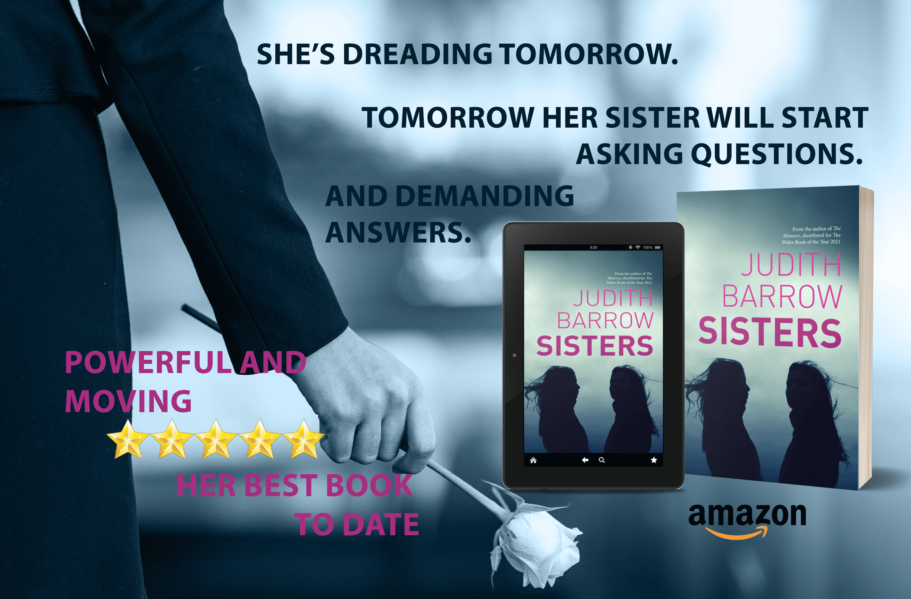
None more so than in Sisters, a story built around one of the most devastating tragedies a family can endure.

Sisters is on promotion at 99p ” A moving study of the deep feelings – jealousy, love, anger, and revenge – that can break a family apart”

Readers have asked what was the inspiration for Sisters. I can only answer that it was an incident that I witnessed as a child. An event that tore in two a family that lived nearby. It’s something I’ve never forgotten.

I’ve had some wonderful reviews for Sisters. This is one of my favourite

Review: http://tinyurl.com/3yjkz7ku

I’m going to borrow some words I used when I reviewed The Memory – “absolutely compelling, a story superbly told, and an entirely unforgettable emotional experience”. I used the word “stunning” a few times too – and although this is a very different book, the words seem equally appropriate. With this book, the author has produced another that packs a considerable emotional punch, coupled with an original story that had me pinned to the seat as I read it from cover to cover in one sitting.

A short prologue hints at what is to come, but the book opens in 1970 – with a family who will be torn apart by a tragic accident, where the blame settles with young Mandy, and its consequences are devastating. Sent to live with her uncle and aunt in Wales, they uncover the truth about what happened – that she was unable to share with her parents – and show her the love she needs to move on, to build a new life as Lisa, and to rebuild her relationship with her mother. Meanwhile her older sister Angie, wracked with guilt after setting up an alibi to escape any consequences for her own actions, flees her home and her life follows a difficult path that will prove hard to escape. The narrative resumes in 1983 – when Lisa returns for her mother’s funeral, she finds that her estranged sister’s earlier actions and later life choices have trapped her in a marriage fraught with abuse, both physical and emotional, with no means of escape. Angie’s husband has an agenda all of his own – and, along with a friend from their shared past, the sisters need to work together to bring down a man capable of appalling acts and cruelty who has become a most unlikely pillar of the community.

My goodness, the author’s telling is so much better than that – but this book is far more than its story. Mandy’s voice – that of a confused child, torn between her own grief, her sense of right and wrong, and her love for her family – tears at your heart. We hear Angie’s voice too – the way she deals with her own guilt and justifies her actions – and any sympathy is, at first, difficult to find. The father who rejects his own child, and the mother who condones it – that’s even more complex. But when Mandy – now Lisa – achieves some redemption, we see Angie’s life heading in a different direction. And while there might be some possibility that she reaps what she deserves, the reader’s compassion builds when we see what a mess she’s made of her life. Her husband is the truly evil one, who will stop at nothing to get what he wants – but the strength of character that Lisa has developed, and that really emerges through the writing, means that there might just be some possibility of him being stopped in his tracks.

And I’m back telling the story again – and I really don’t mean to. The character development is tremendously strong – but so is the story’s backdrop, the community that closed ranks against a small child bullied mercilessly and driven from her home, and the differences once thirteen years have passed. And there are the small background details that capture the context and era for both the past and present story – so subtle you barely notice, and really cleverly done. But the most unforgettable thing about this book is the way it makes you feel, by skilfully telling a story that can’t fail to engage the full range of your emotions. And it never feels like manipulation – these are real people who you grow to care deeply for through the course of their experiences. The book’s conclusion is satisfying in every possible way – and this is the point when I really won’t tell you the story, because that would be entirely unforgivable.

A family drama, perhaps a thriller in parts – perfectly structured and beautifully written, tender and gritty, this is a book that defies placing within one genre, and is all the better for it. All I can say is that I entirely loved it – one of my books of the year, and I couldn’t recommend it more highly.

Sample:

Part Four June 1981

Chapter Forty-Three

I’m holding the rail at the top of the steps of the bus and peering through the window. It doesn’t help that it’s dirty and smeared with rain. But I can see Micklethwaite is run-down. Shabby.

Though the doors squeal open I can’t make my legs move. I don’t look at him, but I can sense the driver’s impatience and curiosity, and worry for a moment that he’s recognised me. He’s older, but I know he’s the man who used to be the school caretaker. Can’t remember his name but I wait for him to speak. The old familiar fear prickles my skin, I gulp against the sudden tears thick in my throat.

But all he says is, ’On or off, miss?’

I don’t look round at him when I go down the steps clutching my only luggage, my small, blue suitcase. I’m not intending to stay in Micklethwaite long. Standing on the edge of the flagged square, I look around at what used to be the new shops and flats. It’s depressing, exactly as Mum described it last time she was in Ponthallen. She’d said it had deteriorated beyond recognition and she was right. Most of the shop fronts are boarded up, the windows of the flats above covered in yellowed net curtains or wrecked blinds hanging lopsided. Empty crisp packets and torn greasy chip cartons wrap themselves around the iron railings once fixed to protect the young saplings, now fragmented twigs.

Except for a group of hooded youths slouched in front of an off-licence, the windows plastered in red and orange posters to entice customers in with offers of knocked down beer and wine prices, there’s no one around. What had been there before?

I can’t remember. Then it comes to me; it was the hairdressers, Mavis’s Waves and Curls. Mum used to come out of there once a month with the same tight perm that all the other women had. And each time, red-faced with an embedded line from a hairnet across her forehead, Mum swore she’d find a different hairdresser. Each time it had taken until the evening for that line to fade.

 Angie and I used to tease Mum about it.

The thought makes me feel wretched, broken. Broken was how I felt the last time I was in Micklethwaite, carrying a burden that would be with me all my life. I didn’t think of it in that way then; after all I was just a kid. But I do know no one wanted me here at the time. The sideways glances of hatred and recrimination drove away that feeling of belonging. It’s odd; I haven’t thought of it as home for a long time. I belong in Ponthallen now.

And as for Angie ‒ Angela, I’m not sure how I’ll feel when I see her. It’ll be the first time in over eleven years. The first time I’ll speak to her after my life altered completely because of her.

Links:

Amazon UK: http://tinyurl.com/2r2bu3z4

Amazon.com: http://tinyurl.com/7cw4ss8b

Amazon.com aus: http://tinyurl.com/4rh35v6d

Social Media links:

https://judithbarrowblog.com/


https://twitter.com/judithbarrow77


https://www.facebook.com/judith.barrow.3


https://www.honno.co.uk/authors/judith-barrow

https://www.bookbub.com/profile/judith-barrow

Our One and Only Adventure in a Helicopter #MondayBlogs #Memories #photographs #Adventures @NewZealand @MountCook

We’d wanted to go to New Zealand for years. And one of us had wanted to go in a helicoptor for … well… for a long time. So, when the opportunity came, and finances allowed, we went. What I didn’t know was that someone had booked a trip to the summit of Mount Cook.

The New Zealand Southern Alps are a range of mountains formed millions of years ago by the clashing of the Pacific and Indo-Australian tectonic plates. Mount Cook (also called Aoraki – Cloud Piercer) at 3753 metres is the highest peak. And the highest place I’ve ever been – and most probably ever will go. It was truly spectacular. And, if I’m honest, rather Intimidating. But, if we’d gone before 1991, it would have been even more nail-biting. In that year a mighty avalanche sent millions of tons of debris crashing onto the glacier below, losing ten metres from the summit and completely changing the eastern face of the mountain.

Mount Cook is bordered by two glaciers: the Tasman Glacier to the east and the Hooker Glacier towards the west coast. I think, at this stage I was just hoping we could land safely… and not on a glacier.

Mount Cook, helped Sir Edmund Hillary to develop his climbing skills in preparation for the conquest of Everest at the age of thirty-three.On the twenty-ninth of May 1953, at around 11:30am he and his Sherpa mountain guide Tenzing Norgay successfully reached the summit of Mount Everest (8844.43m), becoming the first man to stand on the top of the highest mountain in the world.

The first recorded ascent of Mount Cook is by the New Zealand climbing trio of Jack Clarke, Tom Fyfe and George Graham, who reached the top of the mountain on Christmas day in 1894.

According to Māori (Ngāi Tahu) legend, Aoraki and his three brothers were the sons of Rakinui (the Sky Father). While on a sea voyage around the Papatūānuku, (the Earth Mother) their canoe became stranded on a reef. Aoraki and his brothers climbed onto the top side of their canoe when it overturned. The freezing south wind turned them to stone.

Those tiny figures are us, together with the other passenger and the pilot. As I’d glued the photographer to my side when we first got out of the helicopter, I haven’t a clue who took this photo! Whoever it was, they didn’t get back in the helicopter with us. There could be a story somewhere in that!

It was rather bright… and cold… and windy. The photographer clutched tight hold of his camera. And, as I said, I clutched tight hold to him.

I think by the time he’d finished we had about fifty photographs of the summit and surrounding mountain peaks. He does like to take every angle from all accessible places. I did get a little worried at times at his definition of accessible.

Back safe! It occurred to me afterwards, when I looked back on some of the more difficult hikes we’ve done, how different it is being in control of where your feet go on rocky trails, and how nervous I was actually standing on top of Mount Cook when I knew there was only one way down!

I think this is his “we did it” stance. And let’s go again!

But I was happy to go to the Aoraki Mount Cook village (known mostly for being the top South Island basecamp for climbers, where about only two hundred and fifty people live and there are only around ten pupils in the local school; New Zealand’s only school inside a national park) for some much needed refreshments.

And, anyway, the clouds had descended once more and all flights were off for the day. Phew!!

With Many Thanks to @SallyCronin for Including me in Her Smorgasbord Blogger Weekly Roundup

Walking the Samaria Gorge – White Mountains National Park #memories #holidays #photographs #MondayBlogs

Twenty years ago we went to Crete. Enticed by the write up in brochure in a cafe we decided to walk the Samaria Gorge. The entrance to the Gorge is from Xyloscalo, near the village of Omalos, leads past the old village of Samaria and (sixteen kilometres, that’s ten miles in old money) later eventually ends at Agia Rouméli, a small pretty coastal village with glorious views of the Mediterranean Sea. And tavernas under canopies of eucalyptus and cypress trees. I have to say it was the thought of this last description that persuaded me.

Last week, much to his excitement, husband (the photographer) found some of his photographs taken with one of his old cameras. These reminded me that this was the very first long walk that we actually did together.

Shades of things to come!

When I say “together” I actually mean that, if I didn’t keep an eye on what he was doing, I’d often be walking for ages before realising I’d been talking to myself and he was nowhere in sight. Since then I’ve learned to take a notebook and pen on these excursions so I can sit and write while he takes dozens of different photographs of the same scene, but from different angles, with different lenses, and all that technical stuff.

Armed with strong hiking boots, sunhats, sun cream, bottles of water and snacks we caught the bus at Chania to take us to Xiloskalo at five in the morning. By the end of the hike I was glad we’d started so early; it was sweltering. But I must admit that, at first, I wasn’t quite as enthusiastic as the photographer to be getting up at that time on holiday.

How wrong I was. This is one hike I will never forget.

Declared a National Park in 1962, mainly to protect the endangered Cretan goats (Kri-Kri) which live in the area, the gorge has a rich history dating back to ancient times. Inhabited by people who worshipped the goddess Samaria. It also served as a refuge for Cretan rebels and freedom fighters during various periods of oppression and occupation by foreign powers such as the Turks, the Germans, and the British.

It also is home to the most exquisite plant life

The Cretan ebony is found only in Crete, with purple flowers that adorn the Cretan mountains. Other endemic Cretan plant species are the Cretan crocus, the beautiful Cretan bell several aromatic herbs that thrive on the island. ( N.B. This is not one of husband’s photographs but courtesy of CRETA MARIS. I couldn’t resist showing this gorgeous plant, which wasn’t flowering at the time we went – otherwise you would definitely be seeing various angles and shots of it courtesy of husband)

The above is the narrowest and most famous section of the gorge – called Portes or The Iron Gates. It’s thirteen foot wide and one thousand six hundred and forty foot high. This was the most rocky part to walk – though as far as I remember we did much clambering over and around boulders all the way. I was very glad of the stout boots.

It took us six hours before we reached Agia Roumeli and relaxed outside a taverna with a cold glass of water and a dakos ( a hard barley rusk soaked in olive oil with coriander seeds, chopped tomatoes, oregano and cheese). I asked how this was made but I’ve never quite managed to achieve that special flavour we tasted that day)

The gorge is only open from May to October; in the first and last few weeks of that period it may close if there’s a danger of flash floods.

And I was glad that I wasn’t told before we set off that the gorge is home tofour different snakes, the Balkan whip snake, the dice snake, the cat snake and the leopard snake. Although not dangerous I’m relieved i didn’t see one.

Now husband has discovered photographs from his old camera I’m hoping he can find more from other walks we’ve done over the years. They’ve brought back many memories.

Another brilliant weekly round-up from Sally. And grateful my own post is included amongst all these wonderful writers.