“This gripping story of harrowing behind-closed-doors coercion has tremendous emotional pull.”
LoveReading Says
Domestic thriller fiction at its most heart-wrenching, Judith Barrow’s The Stranger in My House is also utterly un-put-down-able — readers will be desperate for a family broken by cruel coercive control to be reunited.
The novel opens in 1967 when twins Charlie and Chloe are introduced to their “new mummy” Lynne while they’re still bereft at losing their mother to cancer. Early on, Lynne’s behaviour causes alarms bells to ring for the twins — and readers — which only adds to the mounting tension and fear of where things are going, with their father, Graham, vulnerable to emotional manipulation, rendered powerless to do anything to stop his life from careering out of control, which it does at alarming speed.
Before Graham can catch his breath, he’s lost everything, as have his children, who are separated from their father and each other, while Lynne and her bully of a son continue their campaign of cruelty.
Years later, the twins are living separate lives in different parts of the country, both scarred but their hearts lifted by kind souls. And then comes a race-against-time to find each other and save their dad.
Though weighty and harrowing in subject, The Stranger in My House is grippingly easy-to-read in delivery, which makes it a powerful page-turner that will have fans of family drama thrillers reading long after they’d planned to turn out the lights.
Honno is an independent co-operative press run by women and committed to bringing you the best in Welsh women’s writing.
It was established in 1986 by a determined group of volunteers who wanted to increase the opportunities for Welsh women in publishing and bring Welsh women’s literature to a wider public. They asked the people of Wales to show their support for the new enterprise by becoming shareholders in the cooperative and in the first six months more than 400 people bought shares. Honno continues to be supported by hundreds of individual shareholders who believe in its work.
True to its roots the press still only publishes work by women of Wales. Most of Honno’s titles are novels, autobiographies and short story anthologies in English as well as Classics in both Welsh and English. We have in the past also published poetry, children’s and teenage titles and books in both Welsh and English.
Over the years the Press and its titles have been awarded many prizes.
It is guided by the Honno Committee of volunteers who set the strategic direction of the Press, decide the publishing programme and manage the office and staff. The Honno office is located in the mid-Wales coastal town of Aberystwyth.
Honno receives financial support from the Books Council for Wales.
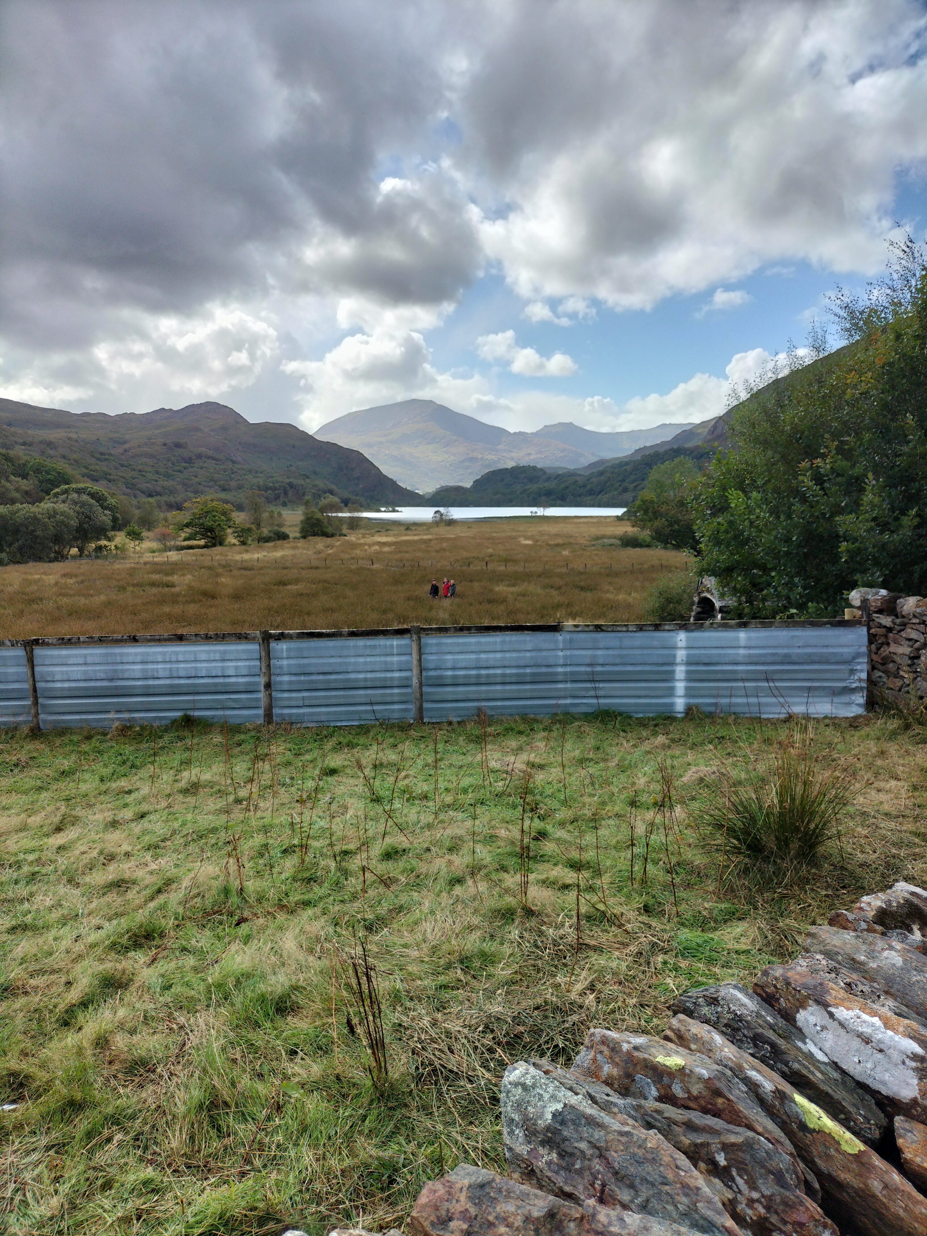
The two hundred acres of Craflwyn estate is set in the heart of beautiful Eryri (Snowdonia), an area steeped in legend.
A walk of two halves today. We parked at the Crafwlyn Estate car park, just outside Beddgelert and, having read the information board, the Photographer and I decided to do the Green Walk. The sign promised an easy to moderately difficult ascent of only one and a half miles to the viewing point. It was the “spectacular views” that clinched it.
The heather was glorious. The path was … somewhere…
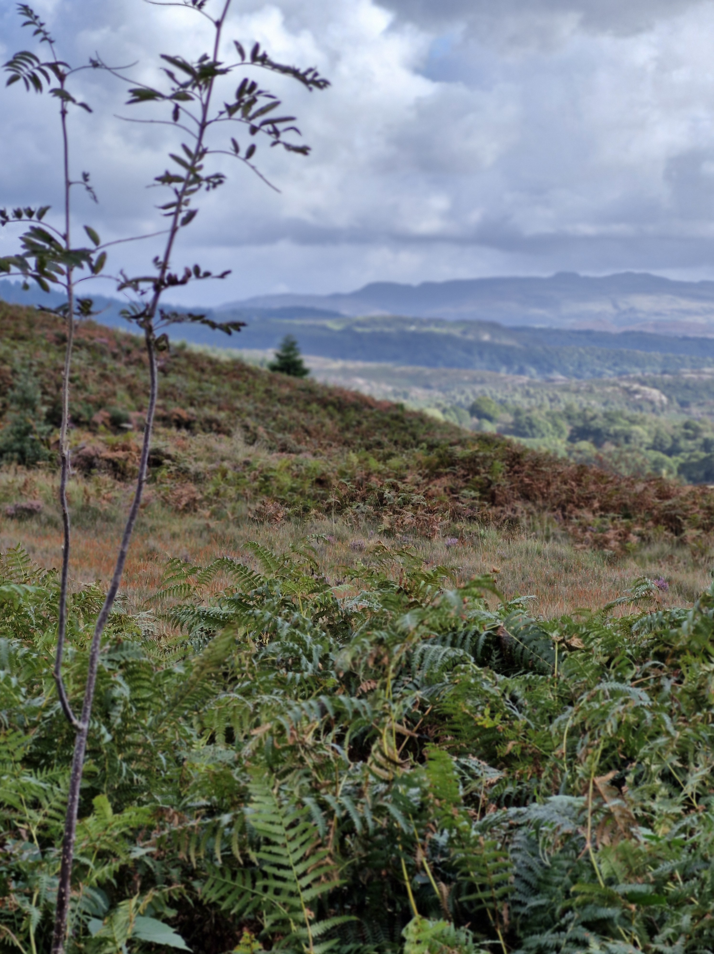
The walk turned out to be difficult, and certainly longer than one and a half miles. Quite the opposite in fact, and it and became steeper almost immediately, and very rocky. We assumed it would level out at some point but it never did and we just kept climbing and climbing.
Dinas Emrys is a rocky and wooded hillock near Beddgelert. Rising some seventy-six metres above the floor of the Glaslyn river valley, it overlooks the southern end of Llyn Dinas. The legend is that it’s where Merlin once trod and where a dragon still sleeps. At the top are the remains of a square tower and defensive ramparts belonging to the ancient princes of Gwynedd. We never saw that at any time over the week… ” the square stone tower at Dinas Emrys in Gwynedd, Wales is believed to be the base of a 12th century tower or citadel. The tower is now in ruins, but its rectangular shape and local rubble masonry are still visible. According to legend, the tower was built by King Vortigern as part of a castle he wanted to construct on Dinas Emrys. However, the walls would mysteriously collapse each night, which led Vortigern to seek the help of Merlin the wizard. Merlin revealed that two dragons, one red and one white, were fighting in a pool beneath the castle. Vortigern and his men dug into the mountain to release the dragons, and the red dragon eventually won the battle. The castle was then named Dinas Emrys in honor of Merlin, and the red dragon became a symbol of the fight against the Saxons.
oplus_32
Just at the point where the ferns and tufts of coarse grass petered out, and the way in front of us rose sharply and consisted of sharp rocks, it began to rain and the view disappeared. We turned and scrambled back down – the second time we’d turned back on a walk that week.
One disgruntled Photographer…
Twenty minutes later and wet through, we saw a sign for the Waterfall trail. A footpath lead through the woodland, following a waymarker to the right.
We passed the dragon bench. Too wet to sit on it though.
We walked up some steps to see a small waterfall. But we could hear loud splashing further along the path.
The large waterfall. Apparently deep enough to swim in. I didn’t test that theory.
It was a wonderfully peaceful end to the day – and to our last walk of the holiday.
We’d had a great week. The photographer was keen to get home to start downloading, printing off and framimg his photographs.
I was ready to finish the proofreading of my next book, The Stranger in my House, to be published by Honnoon the 14th November 2024 .
Described as…
“A gripping ‘cuckoo in the nest’ domestic thriller
After the death of their mum, twins Chloe and Charlie are shocked when their dad introduces Lynne as their ‘new mummy’. Lynne, a district nurse, is trusted in the community, but the twins can see her kind smile doesn’t meet her eyes. In the months that follow they suffer the torment Lynne brings to their house as she stops at nothing in her need to be in control.
Betrayed, separated and alone, the twins struggle to build new lives as adults, but will they find happiness or repeat past mistakes? Will they discover Lynne’s secret plans for their father? Will they find each other in time?
The Stranger in My House is a gripping ‘cuckoo in the nest’ domestic thriller, exploring how coercive control can tear a family apart. Set in Yorkshire and Cardiff, from the 60s to the winter of discontent, The Stranger in My House dramatises both the cruelty and the love families hide behind closed doors.” https://tinyurl.com/349ucdat
I’m happy to leave things as they are here. So, until next time … thank you for following the Photographer and I on our adventures.
Moel Hebog (Welsh for Bare Hill of the Hawk) is a mountain in Snowdonia, which dominates the view west from the village of Beddgelert.
This was the next walk we did. I say ‘walk’ as a vague description. And I need to say at this point that we hadn’t read the following review beforehand.
“This is very much a steepish persistent trek from the beginning to the end. The path is very sketchy in places and you have to work out the best way forward. You go around the false peak and a bit further up you come to a near vertical wall bit. Be careful here as a number of false paths on where to go up. Take your time to work out the safe route which is on the left side of the paths. It’s only two-four steps scramble then you are back on a reasonably marked trekking path. This trek is not for beginners you really need the experience of being able to work out safe routes and a little scrambling experience. You also need a reasonable level of fitness as it’s very much a full on upwards & downwards trek, not any flattish areas. When I did it mid May 2024 the forest walk on the descent was impassable as flooded, very boggy so had to walk around the gravel tracks that added around 4 miles to the trek. Really enjoyed this trek, it is physically challenging as you gain height quickly, I would fully recommend trekking poles as they help. The downward grassier slope going down to the forest is steep so trekking poles really useful. Enjoy, take your time and stay safe.”
Oblivious to this review (but with our trusty walking poles, as usual), we walked past Beddgelert Railway Station, then along a lane crossing the railway line.
We passed a farm, said hello to the dog who came out to watch us, and walked through a small wood before the land opened up. There was a stone path across crossing a field, and then a post which indicated we needed to go straight ahead to a stile over the stone wall. (Yes, there had to be a stile!!)
At first the path was a meandering course on spiky grass with golden brown ferns set in a landscape of small outcrops and boulders. (Later in the day, having coffee in a small cafe, we met three young climbers who told us that these boulders were called erratics, glacial boulders or rocks that have been transported by ice and deposited. The type of rock – the lithology – the physical, chemical, and mineralogical properties – that the glacial boulder is made from is different to that of the bedrock where it’s been deposited.)We live and learn!
As we climbed,I took advantage of every photo stop, as usual. (my ‘catching my breath’ time). The landscape was glorious. And there, in the distance, was Llyn Dinas.
We stopped for lunch, debating at this point on whether we’d gone as far as we should (could!) Just then two couples passed, going back down. ” That’s us done,” said one of the men. “We know when we’re beaten. Off for a pint.” They were about twenty years younger than us. We looked at one another, made our decision; if going any further was too much for them, we had no chance. We packed up our things.
So there we are – sometimes ignorance is bliss. Or very foolish. But it was a lovely day, we took our time, had food and water – and knew when we’d got as far as we wanted to.
We took one last look at the dark peak of SnowdonIn in the far distance before we turned and made our way down towards the road. “Got some fabulous shots though,” said the photographer, cheerfully. I agreed, relieved to be back on tarmac.
Later, looking back at the walk, I read the following.’The Moel Hebog shield (Welsh: Tarian Moel Hebog) or the Moel Siabod shield, is a large copper-alloy shield from Bronze Age, found in a bog on he north-west slopes of Moel Hebog. Discovered in 1784, it dates from 1300–1000 BC and is now in the British Museum in London.
Richard Blurton (a specialist in South Asian art and archaeology, formerly Assistant Keeper at the British Museum), wrote about the shield in his book The Enduring Image: Treasures from the British Museum (only £209, plus £9.75 postage). He says, “This shield is a splendid example, representative of the rise of large sheet-bronze work in later Bronze Age Europe. Much effort was directed towards the production of ceremonial metal armour indicating the prevalence of the idea of man as a warrior.“
Llyn Dinas is a fairly shallow lake that lies on the valley floor a few miles north of Beddgelert in Gwynedd in north Wales. It is formed by the River Glaslyn. The lake takes its name from the nearby Dinas Emrys, a hill just downstream of the lake where a rock, Carreg yr Eryr (The stone of the eagle), was said ,in a charter of 1198 ,to mark the spot where the boundaries of the three medieval Welsh land division of Aberconwy, Ardudwy and Arfon met. According to Giraldus Cambrensis an eagle used to perch on it once a week, anticipating battle between the men of the three cantrefs.
We walked around Dinas Lake twice. Well, I say that. I should say we attempted to walk around the lake twice.
After that glorious, long day’s walk to Beddgelert, the clouds the following morning promised rain, and it was cold. Not to be thwarted we rugged up and set off.
On that first walk around Dinas Lake, we were attempting the one the National Trust recommended in the brochure we found in the cottage. We later discovered it was 1998 version, so unfortunately, the directions were out of date. Halfway up the hill it petered out into brambles and undergrowth.
Thisactually turned out to be fortunate. Giving up on the idea of cutting our way through the brambles – mainly because we didn’t have secateurs or knives, we backtracked and decide to walk to the end of the lake. Within ten minutes, we had hailstones bouncing down on us and we needed to shelter close to the stone wall under trees, alongside nine sheep who seemed completely oblivious to us. We gave up and went back to the cottage.
The next day, with the weather just about fine, we decided to try Lake Dinas again.
The water was calm, there was a party of canoeists preparing to go on the lake, and on the far side a group of children were being taken up a fast running stream. Dressed in hard hats and waterproofs it looked as if they were participating in a form of orienteering. From the screams of laughter we presumed they were enjoying themselves. Not for us we decided.
We crossed the bridge over the river to the path just as the rain started.
The path is banked by many rowan trees. There was a plethora of berries on them all. Is that a sign of a bad winter to come? Or is that an old wives tale? (as soon as I wrote “old wives’ tale” I wondered why it was called that. Apparently the name “old wives’ tale” comes from the fact that older women would often pass down their advice to the younger generation in the form of sayings that were easy to remember. The “wives” don’t refer only to married women, though. The term came from the Old English word wif, which means “woman.”) Just another rabbit hole I went down!!
At the far end of the lake we saw a farm house with outbuildings. There seemed to be a lot of activity. Despite the rain and being naturally nosy I urged the Photographer on with the words, ” I bet there’ll be a great view looking back along the lake.” It worked!!
This is the farm… Llyndy Isaf, a farm in Eryri (Snowdon) owned by the National Trust, since 2012 (Image: National Trust)
The farm was bought following a public fundraising campaign to preserve it for the nation. It has previously been home to five young farmers on a scholarship, who have managed Welsh Mountain ewes and Welsh Black cattle on the stunning site, which includes several Sites of Scientific Special Interest (SSSI:
Lake Dinas’ geology is important for nature conservation with habitats of saltmarsh, rush pasture, mire, mudflats, and reedbed, so is a natural home to a variety of wildlife, including bird species, such as Red Kites, Pied Flycatchers, Redstarts, Common Sandpipers, Dippers and Grey Wagtails, (a bird twitcher’s dream), over two hundred invertebrate species, and more many species of lichens and mosses, liverworts and hornworts ( bryophytes – non-vascular plants, which have no roots or vascular tissue, so absorb water and nutrients from the air through their surfaces).
When we approached the Llyndy Isaf farmhouse we were told it was a production team for television. They were more than willing to explain what they were working on.The National Trust has been on the hunt for someone to take over Llyndy Isaf farm. The process of choosing a tenant will be documented for Channel 4’s Our Dream Farm with Matt Baker, in early 2025. Applicants are vying for a fifteen year tenancy of the farm by participating in a three-week selection process. The Trust is seeking an individual with a fervour for sustainable farming.
A drone flew overhead filming Matt Baker with the lake in the background at the same time as the Photographer was attempting to take his photograph at the end of the lake. I’m just hoping the drone didn’t capture the two bedraggled people peering over the wall. I guess, when the programme is aired, we’ll see…
National Day on Writing is celebrated every October 20. It’s a day dedicated to acknowledging the significance of writing as both a crucial skill and a form of art. This special day encourages everyone to appreciate and engage in writing activities.
So, I will be holding a workshop on forming characters at the Gwyl Lyfrau Aberaeron Book Festival. Booking available here: https://tinyurl.com/383zymrz
After the death of their mum, twins Chloe and Charlie are shocked when their dad introduces Lynne as their ‘new mummy’. Lynne, a district nurse, is trusted in the community, but the twins can see her kind smile doesn’t meet her eyes. In the months that follow they suffer the torment Lynne brings to their house as she stops at nothing in her need to be in control.
Betrayed, separated and alone, the twins struggle to build new lives as adults, but will they find happiness or repeat past mistakes? Will they discover Lynne’s secret plans for their father? Will they find each other in time?
The Stranger in My House is a gripping ‘cuckoo in the nest’ domestic thriller, exploring how coercive control can tear a family apart. Set in Yorkshire and Cardiff, from the 60s to the winter of discontent, The Stranger in My House dramatises both the cruelty and the love families hide behind closed doors.
“Judith Barrow’s greatest strength is her understanding of her characters and the times in which they live.” Terry Tyler
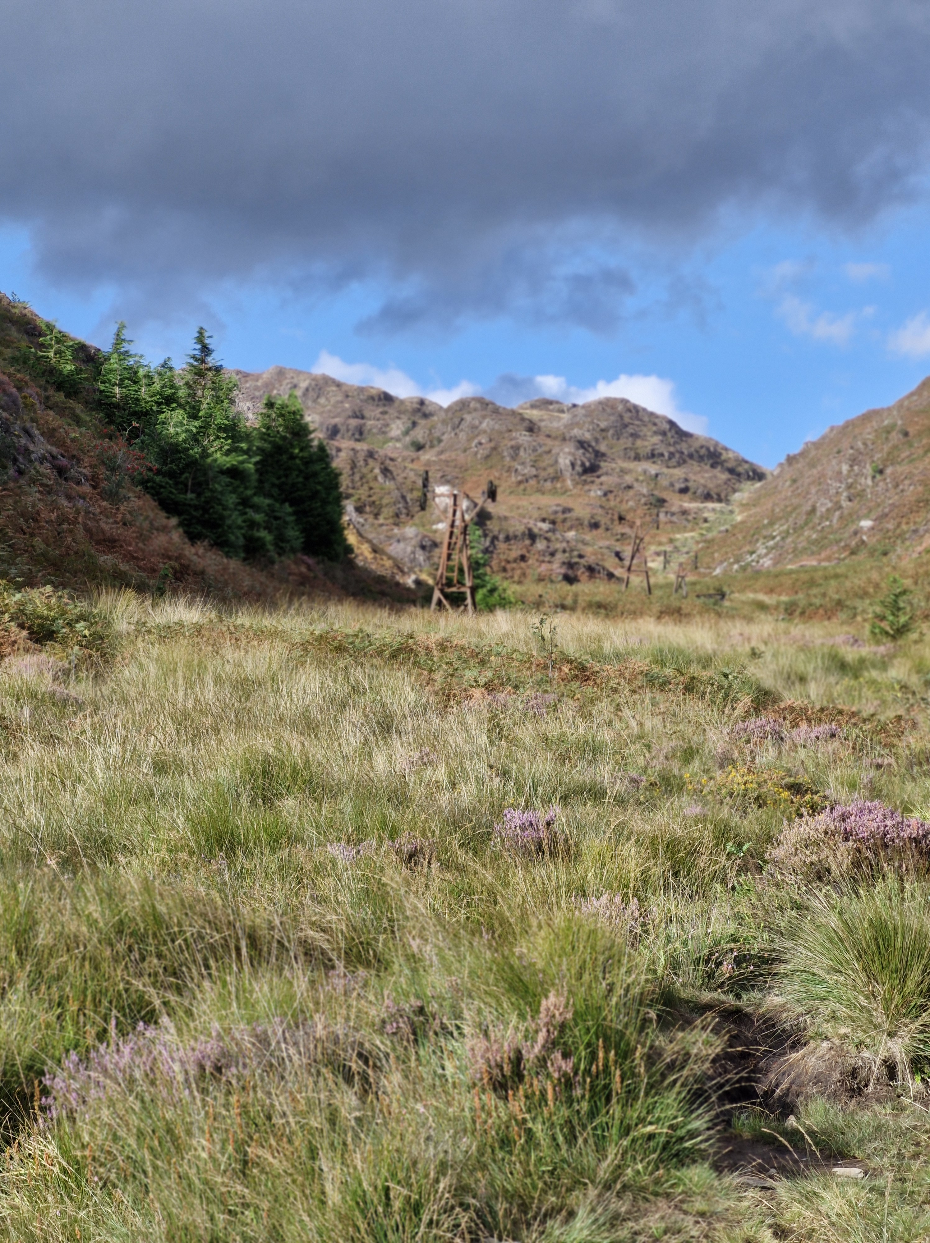
The second day, we knew we needed to take it easy, so we planned a short walk for the afternoon. Around three miles from the cottage that we were staying in was the disused Cwm Bychan copper mine, so we decided to explore.
The start of the walk was from the Nantmor National Trust car park, easy enough to find. We went under the railway bridge (still no steam train), and onto the stony path that led up through woods.
We’d been told these were bluebell woods, but, of course, in September no signs of bluebells, but impressive heather anyway.The area also includes internationally rare heathland, found only in the western coastal areas of Europe that provides habitat for numerous butterflies and birds.
The path wound upwards, sometimes not as distinguishable, always following the stream.
We were tempted to sit here, but I knew if I sat down I might not stand up again; the short walk had turned into yet another climb – and the weather looked as though it was changing.
But, gradually the woodland path changed into easier, wider paths on the open mountain, and I was reliably informed that the remains of the copper mines was, “just around the corner”.
And there it was!
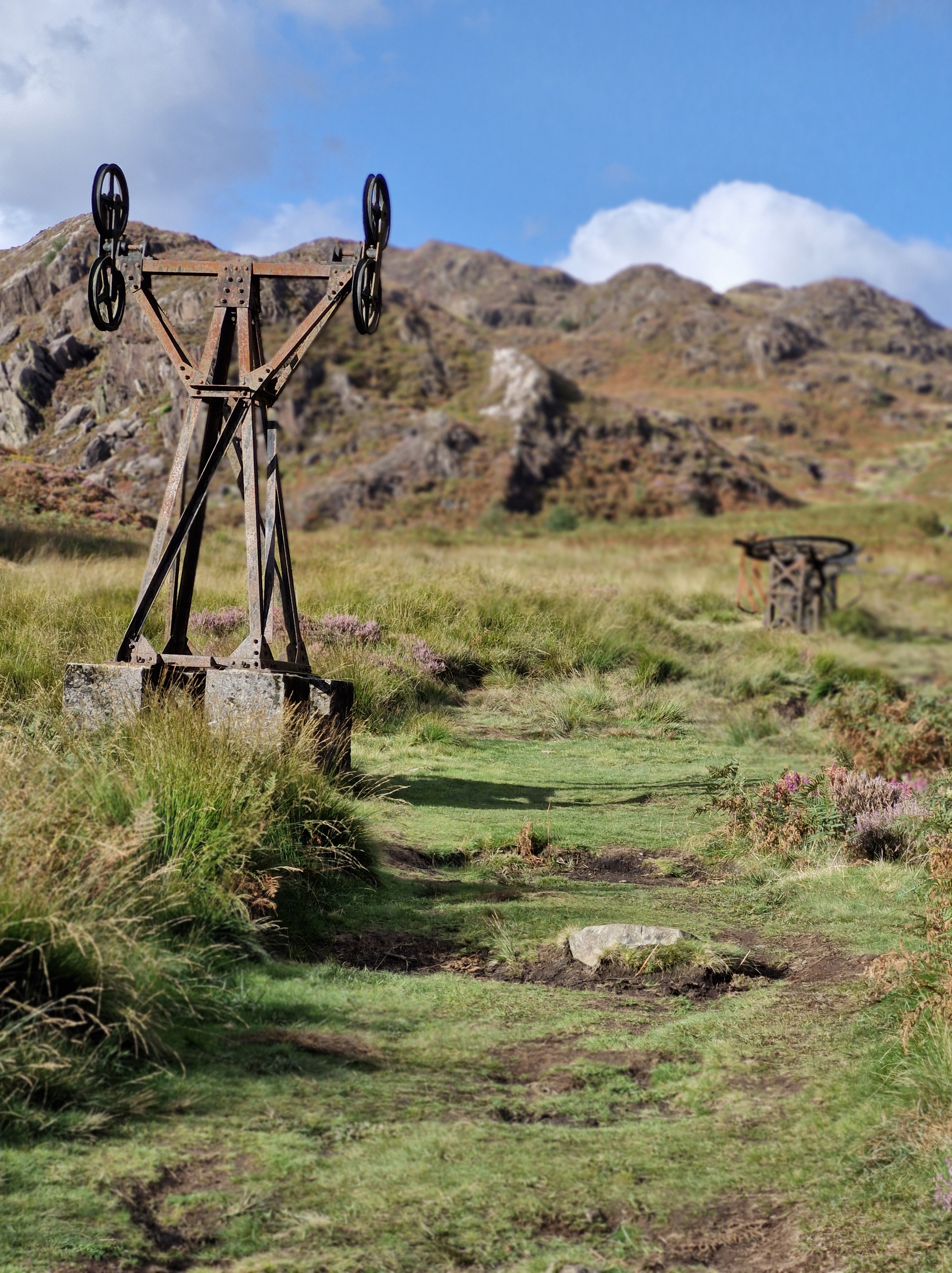
Various relics of that era can still be seen, including the aerial ropeway with its pylons and terminal wheel. And, in the background, the slag heaps of waste copper.
The evidence of the copper mining that used to be carried out here is quite poignant. The silence, broken only by occasional bird calls, the rustle of the breeze through the long grass, the bubbling of the stream, obviously a contrast to how things used to be.
Mining has been dated back to at least the seventeenth century in Cwm Bychan. The mines finally closed in the nineteenth century, then re-opened in the nineteen twenties. It was at this time that an aerial ropeway was built to help remove the Chalcopyrite ore for processing.But the attempt to restart production was short lived and the mine finally closed by the end of that decade.
I needed to research what Chalcopyrite is – a copper-iron sulphide mineral, the primary source of copper metal.
Image courtesy of Wikipedia
I learned that Chalcopyrite, also called Peacock Ore is thought to be an uplifting stone. It may ground nervous energy which allows the body and mind to let go of stress and embrace calm. It also may be used to remove energy blockages, cleansing, activating and aligning the chakras and energy bodies at the same time. To be an excellent aid to increase self-esteem, banish fears and doubts, and soothe the emotions. … fascinating. They must have known this in the nineteen twenties?
The last part of our hike walk was along the Fisherman’s Walk,following the course of the Afon Glaslyn, a sixteen mile sea trout river whose source is a lake in a valley on the edge of Snowdon,and eventually runs into Tremadog Bay near Porthmadog.
We’d rewarded ourselves with a fabulously tasty but light meal in a bistro in Beddgelert and a wander around for an hour or so, before tackling the last part of the walk. After refilling our water bottles we strolled along a paved footpath along the riverside. This will be a doddle, I thought, watching the Photographer indulge in a few photos shots. A nice, calm, wide river.
Further on we crossed a footbridge beside the railway bridge and went through two kissing gates that crossed the railway line (still no sign of the elusive steam engine – to his disappointment and my relief at that point – after the day we’d had I didn’t fancy being run over by a steam train!).
But I wasn’t prepared for what was around the corner…
Glorious though the river was, it had rained quite a lot in the previous few weeks. Now Afon Glaslyn flowed swiftly over rocks and gulleys. And the path is made up of slabs, rocks and, sometimes an indiscernible way forward. I think the only thing I said in the next hour was … “Where’s the path gone?”
See what I mean?
This section was especially challenging – note the handholds hammered into the rock face so we could swing around the corner of the rock on the narrow path … er … stone slabs above the churning Afon Glaslyn.
One last scramble over rocks before we reached the relatively safer gravel path
And back onto the bridge that we’d stood on at the beginning of the day. And a chance for a last photograph.
And … a welcome sight … back to the cosy farm cottage in Nantmor, where we were staying for the week. Ready for an evening of quiet editing of my next book – The Stranger in my House
Nantmor is famous for being the filming location of the 1958 film, Inn of the Sixth Happiness starring Ingrid Bergman and Robert Donat. The film was based on the true story of Gladys Aylward,a British nurse who became a missionary in China in the unsettled years leading up to the Second World War. Nantmor doubled as China and people from the Chinese communities in Liverpool were brought in as extras for filming.
I found an interesting article on the history and repairs of the Popular Fisherman’s path in Beddgelert when ” After winter storms and high river levels washed away a 100m section of the Fisherman’s path, the Welsh Highland Railway swapped its cargo of tourists for stone, reverting to its original purpose for a day. Repaired, thanks to special delivery by Welsh Highland Railway.” Published: 20 February 2023: https://tinyurl.com/32md9b3f
From the lookout point we could see Beddgelert – now only two miles away. All down hill. Very downhill!
The village is in the Snowdonia area of Gwynedd, Wales.It’s thought that it’s possibly named after an early Christian missionary called Cilert who settled there to become the leader in the eigth century. The earliest record of the name Beddgelert appears on a document dated 1258( recorded as Bekelert). The local Welsh dialect often shortens the name of the village to Begél.
It didn’t look very much closer through binoculars, to be honest.
Zig-zagging down the steep hillside to reach Beddgelert, and then through the magnificent Aberglaslyn Pass and on to Porthmadog, is the Welsh Highland Railway, the UK’s longest heritage railway. These trains are the world’s most powerful narrow gauge steam locomotives, and run for twenty-five miles from Caernarfon to Porthmadog. They climb from sea level to over six hundred and fifty feet below Snowdon, before descending to Beddgelert.On numerous walks we heard the ‘toot-toot’ of the train. Many times we waited for it to come into view … until we realised the sound echoed all around the mountains … and it was always miles away from where we eagerly anticipated (well, one of us did!) a “great photo opportunity”.
One of the most sought after/ looked for attraction – from a tourist point of view – is the raised mound in the village, called “Gelert’s Grave” and the statue of the faithful hound. The folk tale is synonymous with Beddgelert. By the way, the ‘hill’ (as the photographer first described it to me) in the background is Bryn Ddu mountain – the one we’d just scambled down.
But the grave was actually built by the late 18th-century landlord of the Goat Hotel, David Pritchard, who created it in order to encourage tourism.
We called in to have a wander around the local church, the Church of St. Mary stands at the end of Stryd yr Eglwys (Church Street). Parts of the building date from the 12th century; the chapel section being originally a part of an Augustinian Monastery. the rest the of the monastery was destroyed by fire during Edward I’s war of conquest. It really is a lovely peaceful church. And welcoming, as the following shows …
The village is also linked with the Rupert Bear stories.
Alfred Bestall wrote and illustrated some of the stories whilst he lived in the village, in a cottage at the foot of the Mynydd Sygun ( Sygun Mountain). There is even a small area known as ‘Rupert Garden’ in the village, dedicated to the Bear; a short walk from Alfred Bestall’s old home.
Lying in the heart of Snowdonia, Beddgelert is small, and a beautiful conservation village in the heart of the National Park, nestled below mountains at the confluence of the Glaslyn and Colwyn rivers. The path alongside the Glaslyn river was the last section of our walk back to Nantmoor. The path sounds so innocuous doesn’t it? Especially when it’s called the Fisherman’s Path – images of quiet contemplation, the swish of fishing rods, the ripple of water…
‘It’s the longest walk we’ll do,’ said the Photographer, ‘But it’s such a glorious day, and we’ll get some gorgeous views. Better take the walking poles as well.’
I know. I know… ‘walking poles’ should have been the clue!
It was a gentle, if somewhat a rocky start to the walk through the woods.
And then the Afon Glaslyn (Glaslyn River) came into view. ‘We come back to here along the river bank,’ the Photographer said.
‘Oh, lovely, said I!’ And meant it… then
We went through the kissing gate, over the road bridge, turned left on the road, until we saw aNational Trust sign for Coed Aberglaslyn (Aberglaslyn Trees) and followed the footpath towards the stream.
So far so good. “Follow the waymarkers up through the woods”.But the waymarkers had long since disappeared. And here I need to say, the following was completely my fault. “Follow the path to the stream”, the directions read. So I did. But you would think, after all these years, the Photographer would know I have no sense of direction.
And here is the stream.
“Turn right,” the directions read. Across the stream? Which was flowing fast and deep. We read, and re-read the directions. We searched for a path.
For half an hour.
Suddenly we were joined by a couple. ‘We have the O.S.map on our mobiles,’ the man announced. ‘We know the way. You can follow us.’
So we did…
For almost an hour we followed them, clambering over boulders, up along boggy paths (sheep trails, they turned out to be), splashed through water, until we reached the top of the hill. To discover it wasn’t the top of the hill. Whereupon the woman turned to us and cheerfully said, ‘We’re not very good at orienteering. I think we’ve gone wrong.’
We went our separate ways. We slipped, negotiated the boulders, slithered through mud, back to the stream.And then back to the bridge. And there we found a waymarker – hanging off a post, pointing to the ground. We looked around – and there, going up through the wood were long narrow indents in the ground… steps!!Of a sort.
‘It says in the directions there should be a stile at the top. Chance it?’ the Photographer asked. ‘Or would you rather give up?’
A stile!! Buthis words sounded suspiciously like a challenge. I’ve never been able to resist a challenge…
We tackled the way up the hill, winding through the trees. It turned out there were just over a hundred of the so-called steps, which necessitated hanging onto trees and hauling ourselves up branch by branch – or hauling one another up – in places. We had lots of stops for breath. And we needed those walking poles.
Until we were actually on Bryn Ddu. The halfway point to Beddgelert. Finally we were on the right track.
We stopped for a few photographs.
Before setting off again to search out the base of a tower, built on a prominent outcrop at a viewpoint overlooking Aberglaslyn Pass. The whole structure is built on a stone plinth which forms a narrow terrace around the tower. Thought to be a wartime lookout post.
From the lookout point we could see Beddgelert … in the distance. And the narrow trail winding its way down the hill. We stopped for much needed refreshments, and to catch our breath before tackling the next half of the walk.
Promoting my books has always been something of a dilemma with me. Going to book fairs, giving talks, book signings, not so much; I always assume people are there because they want to be. They want to chat, to look at my books, to discuss the way I write – sometimes they way they write. It’s fun, I love meeting people. I love talking about my books, why I wrote them, how I came up with ideas, what they mean to me. The reviews readers have given them. I’m always grateful.
But how to talk about my books with people I just have met, casual acquaintances- even perfect strangers? It’s not something I do. It even makes me uncomfortable if I’m in the company of someone who does this, especially in public places, spaces that have nothing whatsoever to do with books, reading or writing. Although I admire that writer’s ability to pluck the subject of their work out of the air and present it to someone they have just met, or engineered a meeting, it’s not something I could do. After all, would I want anyone to feel cornered into buying a book, to be pressurised? Well, no, I wouldn’t. I’ve seen it happen, I’ve seen the reactions of the ‘cornered one’.
It’s a fine line in talking to a potential reader, to presenting my books to someone who might not be interested at all – who escapes with relief, albeit having had to buy a book!. Embarrassing!!
Social media, I know, is different in that there is no real life face to face appearance – it’s one step away. Even so, having followed many writers of all genres on the various platforms, I’ve seen those who singlemindedly try to sell their work, and those who use social media in it’s true sense (as a friend once said to me ” the clue is in the word ” social”). And there are those wonderful people who, so generously share the work, the promotions, the blogs and reviews of others. I’m grateful to those I have ‘met’ and become friends with in real life, as well as on social media.
And there’s another predicament for me when it comes to promoting my books – which platform am I most comfortable with. Which platform can I share general news and chat with, as well as publicity for my work … and which not.
Lately I decided to delete my Twiiter/X account. When the name changed I wondered why it had, what would be the difference, how would this formerly named Twitter be used. I have/had many friends who used and still use this platform in the way I did – to chat about life in general, to talk about books, reading, and writing.
But, gradually I saw something change on the feeds I received on Twitter/X. I’m not talking about all the “retired Generals/ Government Officials/ Admirers of our profiles etc. Bots, eager to get to ‘know’ us, that anyone on this platform (and other platforms, of course) receive. I mean the constant barrage of race/gender/political hatred, that was suddenly there. People, real people, eager for (bullying) us to join in, to follow whatever drum they are so fanatical about. For me (and I stress this is only me), it all got too much. I retreated – with a sigh of relief.
In a way it’s made me sad. Through the years I built up a moderate number of followers on Twitter; people I followed, who shared my passion for writing, for books; a lovely community. But the insiduous invasion of nastiness became something that affected me, my moods, my emotions. Perhaps I need a thicker skin? I was told by some of my real friends to ignore the constant chatter of predudice. But I couldn’t, and disn’t want to. It was too much. Circumventing these things in real life can be difficult enough, why did I need to be confronted with it on the screen? The screen where I write stories that I enjoy writing, where I chat and share emails, enjoy other social media platforms? So I made the decision and left Twitter/X.
I’m hoping by joining Instagram/Threads, and continuing on other platforms I will, eventually, connect again with the writers I got to know over many years. But, for my own peace of mind, it will never again be through Twittter/X.
Because I write about family dramas, family situations, I’ve always been aware of the relationships between people, between family members: the love, the loyalty, the friendship, the instinctive support. But also, I’m aware of and write about the dislike, the jealousy, the rivalry, the misunderstandings, the battle for control.
I don’t need it in the surreal world as well.
And so, a footnote: I’m not going to try to promote my books here. But … I do have links!!If you care to look for them…
Seeing the cover of the next new book revealed is always a thrill for any author, so I am elated to be able to finally show the cover of The Stranger in My House.
A gripping ‘cuckoo in the nest’ domestic thriller
After the death of their mum, twins Chloe and Charlie are shocked when their dad introduces Lynne as their ‘new mummy’. Lynne, a district nurse, is trusted in the community, but the twins can see her kind smile doesn’t meet her eyes. In the months that follow they suffer the torment Lynne brings to their house as she stops at nothing in her need to be in control.
Betrayed, separated and alone, the twins struggle to build new lives as adults, but will they find happiness or repeat past mistakes? Will they discover Lynne’s secret plans for their father? Will they find each other in time?
The Stranger in My House is a gripping ‘cuckoo in the nest’ domestic thriller, exploring how coercive control can tear a family apart. Set in Yorkshire and Cardiff, from the 60s to the winter of discontent, The Stranger in My House dramatises both the cruelty and the love families hide behind closed doors.
This cover reveal after a glorious day wandering walking around the Ty Canol National Nature Reserve with the friendly Pembrokeshire U3A Natural History Group.
Ty Canol is the largest block of ancient woodland in West Wales. It’s wonderfully peaceful, an atmospheric mix of ancient oak woodland and pasture, set against the backdrop of the magnificent Preseli Mountains of northern Pembrokeshire.
To the north is Hagr y Coed (translation – ‘Ugly Wood’), an area of wet sessile oak, ash, and birch woodland. South is Carnedd Meibion Owen (translation – the Cairn of Owen’s Sons), so named because of the cairns that rise from the rocky outcrop.
Many of the trees are covered by epiphyte ferns and lichen, many of the latter are extremely rare.
These are not parasitic on the supporting fallen and bent branches, they grow on them only for the support they give. Apparently there are over four hundred varieties of lichen in these woods. They thrive, both because farm animals are allowed to graze in parts of the area, and because oak trees are culled in others, thus creating areas that let in the light: ideal for the plethora of light-loving lichens
I almost expected Frodo Baggins to pop out from behind one of the twisted oaks. Ty Canol,purported to be over six thousand years old, really is a fantastical place
Ty Canol, managed by Natural Resources Wales (NRW) together with the Pembrokeshire Coast National Park Authority is part of an area famous for its achaeological sites.
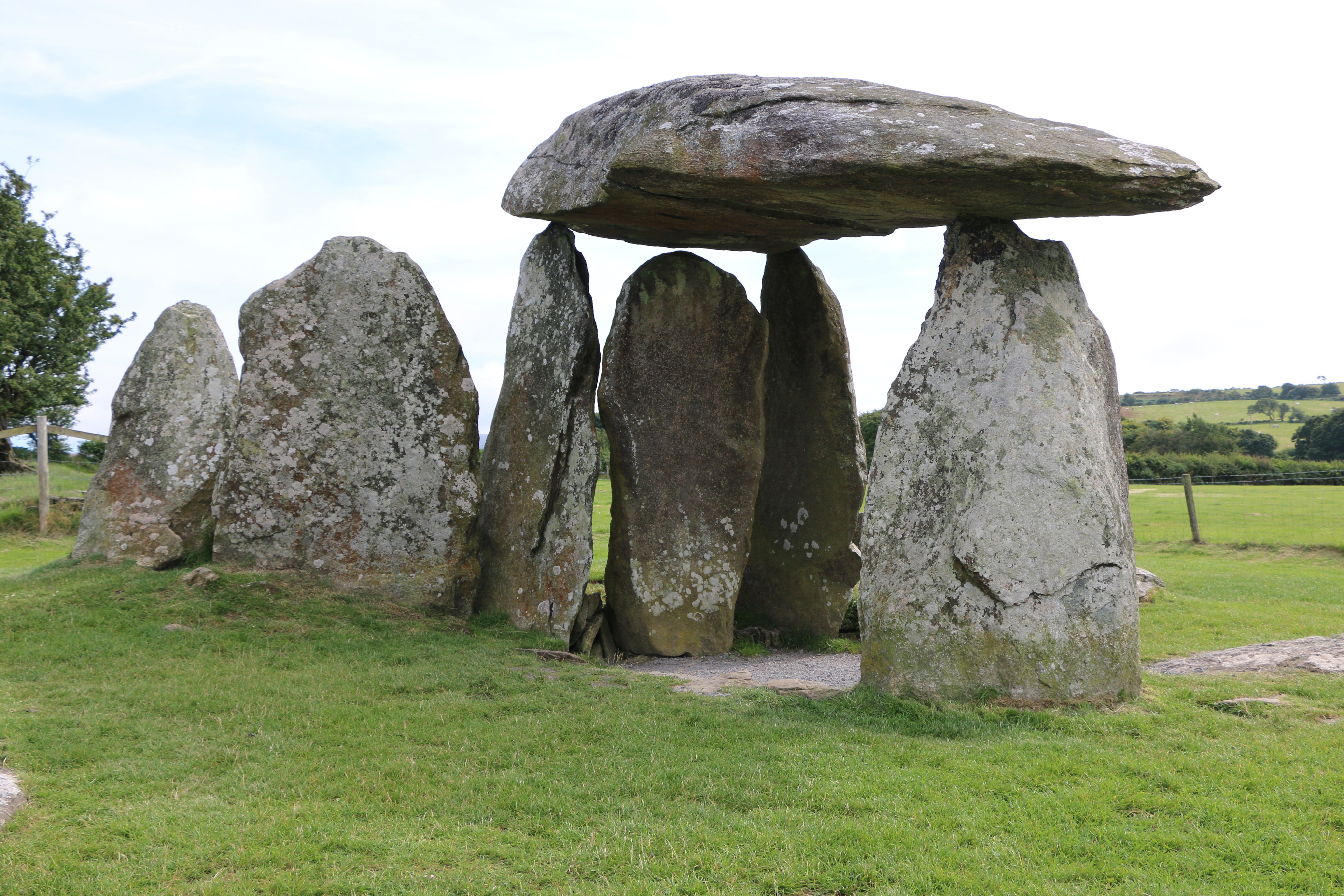
Ty Canol is the backdrop for Pentre Ifan, the famous Neolithic Chambered Dolmen that is thought to date from 3,500 BC.
This is a Cromlech or a Dolmen, typically built with several large upright stones and a cap stone on top. At the time it would have been an inderground tomb, covered by a mound of earth, but today, all the stones are exposed.
Having detoured to take a last look at Pentre Ifan we made our way back home by the scenic routeof Mynydd Preseli, passing Cerrig Lladron .
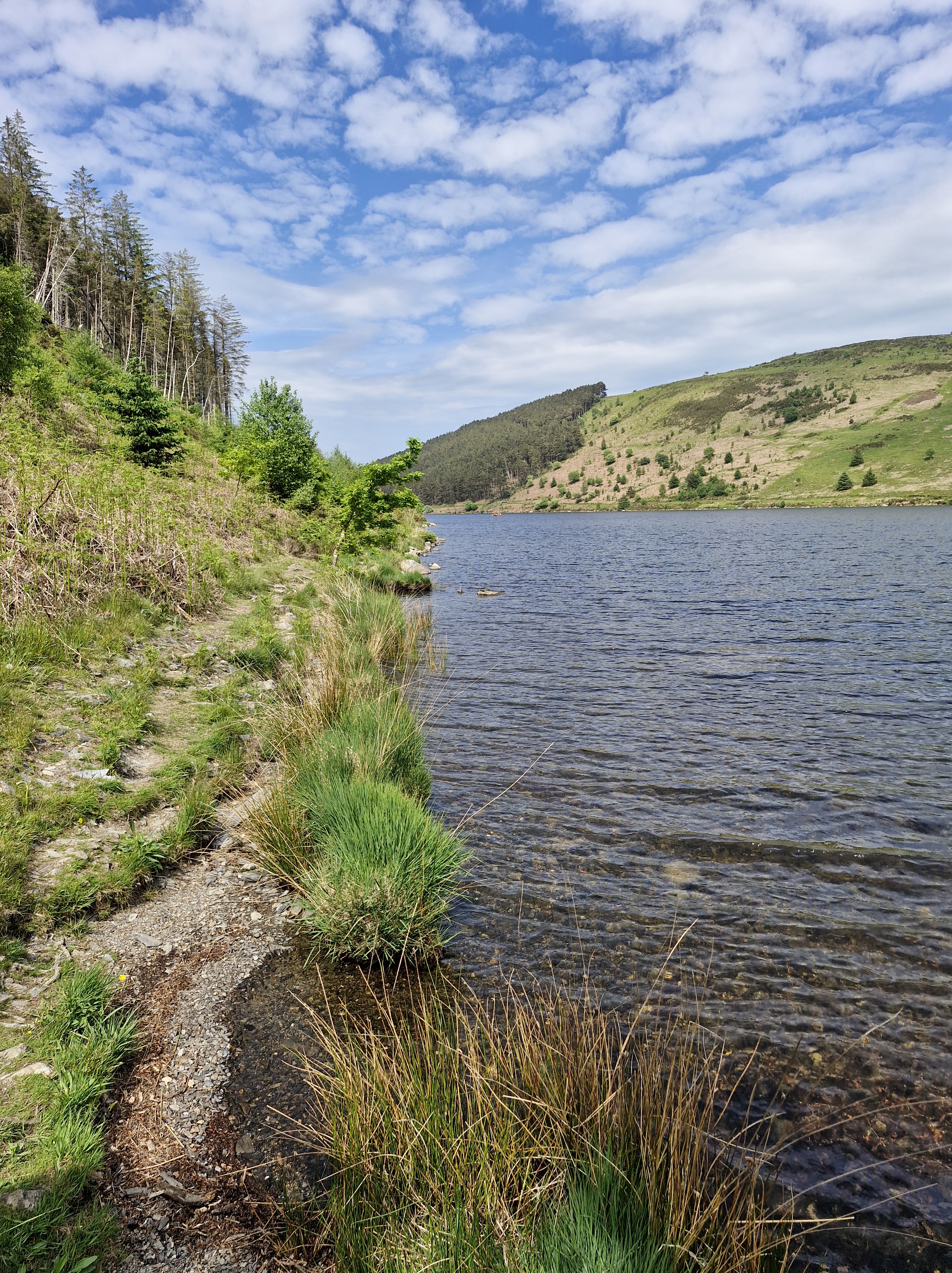
Llyn Crafnant and LlynGeirionydd are separated by the forested slopes of Mynydd Deulyn (Mountain of the Two Lakes) and lie within wonderfully scenic valleys where the Gwydyr forest meets the lower slopes of the Carneddau mountains in Conwy.”The lakes are about a mile apart,” said the photographer casually. “The walk’s about five miles.” What actually happened was that we took the circular route which covers a distance of eight miles and involved some steep climbing.
But, at this point I have to say that wasn’t his fault. We ended up – or should I say – started off walking in the opposite way to the route in the book, having parked in the car park nearLlynGeirionydd, instead of the one near Llyn Crafnant.
This was due to the fact that, at one point, the SatNav took us in the wrong direction. It’s always the SatNavs fault, you know; we once got stuck on a very narrow dirt farm track faced with a sign that joyfully said in large red writing, ” Use your eyes, the SatNav lies”. I think I might have said that before, it’s something I bear in mind when sitting by a certain irate driver having to turn back on a journey.
Anyway, I thought, it’ll be alright; we’ll just read the directions backwards.
I waited on the edge of the grass while the photographer took his first photo of Llyn Geirionydd.
Gwydir Forest is named after the Gwydir River, which takes its name from the ancient Gwydir Estate, established by the John Wynn family of Gwydir Castle, who owned this area (Gwydir is translated as River with Red Banks) The land here was once dominated by lead and zinc mines. Some of the mines have been partially restored and made safe for visitors, but we didn’t visit; our sights were set on getting to Llyn Crafnant Though we did pass an old restored engine-house, and also the waste tips, now left to be naturally covered over.
The First World War had highlighted a shortage in wood production and the forest was stripped bare at the time because many of the early forestry workers, former employees in the forest’s mines, had no experience of forestry. This caused the 1919 Forestry Act to be passed and Gwydir Forest was acquired from Lord Ancaster by the Forestry Commission in 1921.
Most of the original plantations have now been felled and replanted as part of the forestry cycle. We passed quite a few places where this was happening.
The majority of the forest is conifer such as Japanese larch, Norway spruce and Scots pine but apparently, over the last two decades there has been more Welsh Oak, ash and beech planted to give a more varied and softer outline to the forest
“When we get to the top of this track, there’s a little bit of a short climb and the track narrows a bit,” said the Photographer over his shoulder as I puffed and panted behind him. ” Don’t worry, it’ll be so worth it for the view.’
The track did narrow a bit indeed. As the directions said, ‘…into a steep narrow footpath, less than forty centimetres wide (that’s about sixteen inches in old money) in some places, on an unmade and uneven surface, where you can expect mud, rocks and tree roots.‘. The embarrassing thing is, just as I was wobbling leaping gazelle-like from rock to another a young couple (stressing young here!) ran past… with a dog … very quickly.And they even had the breath to wish us a cheerful “good morning.”
Every now and then we caught glimpses of the view. Went past a stile. Down a wider path. Through a gate. Saw the obligatory cow. And then…
The Photographer got his first proper shot of Llyn Crafnant on the northern edge of the Gwydir Forest.
And then lots more. It really is a glorious place
One last look and we walked away from Llyn Crafnant …
Following the arrows we crossed over the road into a small wooded area. And there the arrows stopped. We looked around: there was a stile in the far corner, but it was broken, covered in brambles and branches and looked unused. On the other side of the clearing there was a broad track. After some discussion we chose the track. (later realising we should have tackled the stile).
After an hour of walking up the never-ending road we stopped for breath, and for the Photographer to revell in the scenery and take many photos of the craggy slopes of Mynydd Deulyn.
And for me to have a rest. It wasn’t until we got back to the car that I realised I had somehow managed to take the attractive shot below whilst I was rummaging in my rucksack for the fourth, and last, bottle of water. Naming no names, but someone dared me to include this in the post – and I’m never one to pass on a dare. Which is probably the reason I find myself on these hikes walks.
Another hour of uphill, round a bend, and the road began to descend, until we were …
Back to the start…
I’m often asked what do I think about when I’m walking and with not enough breath to talk. I must say not having enough breath to talk isn’t something that often happens to me. But usually I’m taking in what’s all around us. We walk in so many diifferent kinds of places, so I just soak up the sights and the sounds whether in the country or in more urban areas.
But there are times when I’m thinking how to describe what I’m seeing, wondering if it will fit into a scene in the book I’m currently working on – or intend to work on. Sometimes it will, sometimes it won’t. It’s usually the latter, but that’s okay. And if I can keep it in mind for when we next stop for the Photographer to capture the scenary, I’ll make notes.
And I remembered that moment, that feeling of almost sinister atmosphere when I wrote one of the scenes in Sisters.
“‘Whoops! Watch your step, Miss Clumsy.’ Said in a jokey manner, it still manages to imply the familiar censure. ‘If it wasn’t for me always looking out for you, I don’t know what you’d do.’ He laughs. ‘Probably kill yourself, one of these days.’ He pulls her close, turns her so they are facing the lake, standing on the edge of the steep banking. The sun is sinking lower in the sky, the black shadows of the trees lengthen, their reflection stretch and waver over the lake, the water rendered blood-red.“
Book Description:
An accident and a terrible lie by sixteen-year-old Angie tears her family apart and her younger sister, Lisa, being sent away. They don’t speak for thirteen years, until their mother’s death brings them together. Lisa quickly realises her sister is trapped in a dangerous marriage.
What does Lisa owe to the family that betrayed her? And if she tries to help, will she make things more dangerous for them all?
A powerful story of domestic violence, courage and forgiveness.
Our one leisurely day: Bodnant Gardens, which nestles in the Snowdonian foothills of North Wales, near Conwy. On a hot and sunny day it took us seven hours to walk around and savour the horticultural delights of the gardens and admire the buildings.
Bodnant (Welsh for ‘dwelling by a stream’) was home to the Lloyd family from the reign of James I until the mid 1700s when it passed to the Forbes family. The parkland was designed into the style of an English landscape, and the earlier house was replaced by an Italianate mansion in 1792, courtesy of Colonel Forbes. On his death in 1820 the estate passed to William Hanmer of Bettisfield Park in Flintshire who extended the garden around the mansion house between 1828 and 1837. In 1874 the estate was bought by Henry Davis Pochin, Victorian industrialist, and his wife. There’s an interesting post on the people of Bodnant here.
2024 marks seventy-five years since Bodnant Garden was gifted to the National Trust by Henry McLaren, The 2nd Lord Aberconway.
Our first glimpse of the gardens was through the wonderful and reknowned Laburnum Arch, a fifty-five metre-long avenue of golden flowers. It was created in Victorian times by Henry Davis Pochin in 1880. He employed Edward Milner, apprentice to Joseph Paxton (landscape gardener, designer of hothouses, and the architect of the Crystal Palace for the Great Exhibition of 1851 in London), to help design the formal garden around Bodnant Hall, including the Laburnum Arch, based on pergola walkways of the 16th and 17th centuries. It is believed to be the longest and oldest in Britain.
Rhododendrons are wild shrubs native to South-East Asia. They were first introduced to Bodnant Garden around 1900, many grown from original seed collected on expeditions in central China, sponsored by Bodnant’s owner, Henry Duncan McLaren the second Lord Aberconway). The plants flourished,producing some of the largest shrubs in the western hemisphere. Then some were hybridised to create varieties that were more compact, more richly coloured,with a longer flowering season. This is Rhododendron ‘Elizabeth’ a compact plant with vibrant pink flowers – the most famous of all the Bodnant hybrids and one that is today found in many domestic gardens. The gardeners at Bodnant are always searching to identify ‘lost’ varieties and propagate those under threat to ensure the future of the collection for many more years to come.
Two of the terraces have ponds, which are home to water lilies and a variety of wildlife (we saw ducks).
The borders on each of the five terraces are planted with careful consideration of the surrounding environment and are in keeping with the year of their creation. They are absolutely wonderful.
We also saw a Harlequin ladybird. These are about the same size as native ladybirds. They range in colour and pattern, but some of the most common forms are black with red spots, red with black spots and orange with black spots.Harlequins have attracted negative publicity since they were introduced in Britain 2004, but in reality they are nothing to worry about. They are known to reproduce quickly, gather in large swarms and compete with native ladybirds for aphids. They have shown signs of cannibalism, consuming the larvae and eggs of other ladybirds. But disease and predators are bringing the population under control. Harlequins can also carry an STD ( What?!) called laboulbenia. It is a fungus that forms little scales on the wing cases, and sometimes white crust on some parts of the exoskeleton, which can be seen with the naked eye.The STD also infects native ladybirds – the harlequin is simply another host for the fungus to live on. (the good news is humans cannot be infected. Sigh of relief!!)
I love reflections in water. The river runs throughout the gardens. Above is the Waterfall Bridge, with its vertical torrent of water on one side, and the calm, reflective pool on the other. Home to wildlife including kingfishers, dippers, heron and ducks. (and tadpoles, lots of tadpoles).
The photographer outside The Poem, a poetically-named mausoleum, built by Henry Davis Pochin. Located in an area of the Shrub Borders within the garden, The Poem is the McLaren family mausoleum. It sits on an outcrop of rock at the end of the valley known as the Dell.
The building below is the known as the Pin Mill. Originally built in 1730 as a gazebo at Woodchester, Gloucestershire, and later used as a pin mill and later still as a tannery, the building was moved to Bodnant gardens and reconstructed in 1938/9 as a pavilion at the south end of the canal terrace. The coat of arms on the building is of the family Surman or Shurmer whose connection with the building is a mystery.(One to solve sometime in the future)
The 2020 Sky Original adaptation of The Secret Garden, based on the classic 1910 novel by Frances Hodgson Burnettwas, was partly filmed in Bodnant Garden. The canopy of the cascading yellow flowers of the Laburnum Arch, the gnarled, fantasy-like woods and Italianate follies, all added to the sense of magic in the film.After a day walking around this glorious place, we could understand why Bodnant Gardens was chosen. It truly is one of, if not the best, National Trust gardens we’ve explored.
“A lovely evening walk,” said the photographer. “With spectacular views.”
It was that last sentence that should have warned me before we set off, I thought as I climbed over the stile and looked upwards.
He’s such a clever clogs: climbing the stile one- handed and taking a video. Hmph!!
A little information here: Pen y Gaer is a mountain summit in the Snowdonia – Beddgelert to Conwy region in the county of Conwy, Wales. It’s the location of a Bronze Age and Iron Age hillfort near the village of Llanbedr-y-Cennin. It’s a natural defensive site. There is a long history of occupation.
There are two Bronze Age cairns on the north-west slope, and extensive prehistoric and later field systems, nearby. The remains seen today are mostly of Iron Age origin, but further earthworks, probably of medieval origin, lie on the south-eastern slopes.
The summit can be identified by one of the large cairns.
Pen y Gaer is three hundred and eighty-five metres high with a prominence of thirty-six metres. (My legs and feet can confirm this!)
The photographer was right though, the views are spectacular.
There’s a broad bank of stones about two metres in width, with a partial kerb of large, irregularly placed boulders before getting to the summit; these are the remains of two defence walls, as well as the outlines of a chevaux-de-frise (A defence, usually a timber or an iron barrel covered with projecting spikes and often strung with barbs of glass).
There are two stone circles. Archaeological evidence indicates that in addition to being used as places of burial, the purpose of stone circles was probably connected to agricultural events, such as the summer solstice.
And, of course, sheep – which moved a lot quicker that we did.
The sun was setting, a mist was creeping in. We were (as far as I was concerned) on top of a mountain. At this point there was a discussion: we could carry on having an adventure and take a track (over a stile) to fields and marshland, and meander until we saw buildings, which could or could possibly not be the cottage we were staying in. Or we could take the windy, steep lane that would definitly lead to the cottage where we were staying.
Whilst someone couldn’t resist one last photo … I staggered sauntered past, with that glass of wine in mind, and carried on.
“A lovely evening walk,” said the photographer, gazing admiringly at photographs on the screen of his camera. “And brilliant scenary.”
I have to admit I agreed, as I soaked my feet in a bowl of cool water. Though next time, I decided, I would check out the mileage… and the ascent … of further ‘walks’.


