Where We Walked Garbad Loch #Arran #Scotland #walks #photography

We parked opposite the Eas Mòr Ecology centre, and crossed the road to pass the Forest at the Falls cafe. “We can call in for a drink and a bite to eat afterwards,” the Photographer says when I look longingly at the table where a couple are enjoying a coffee. The aroma is tempting but Dusk and I follow him up the short, steep path ….

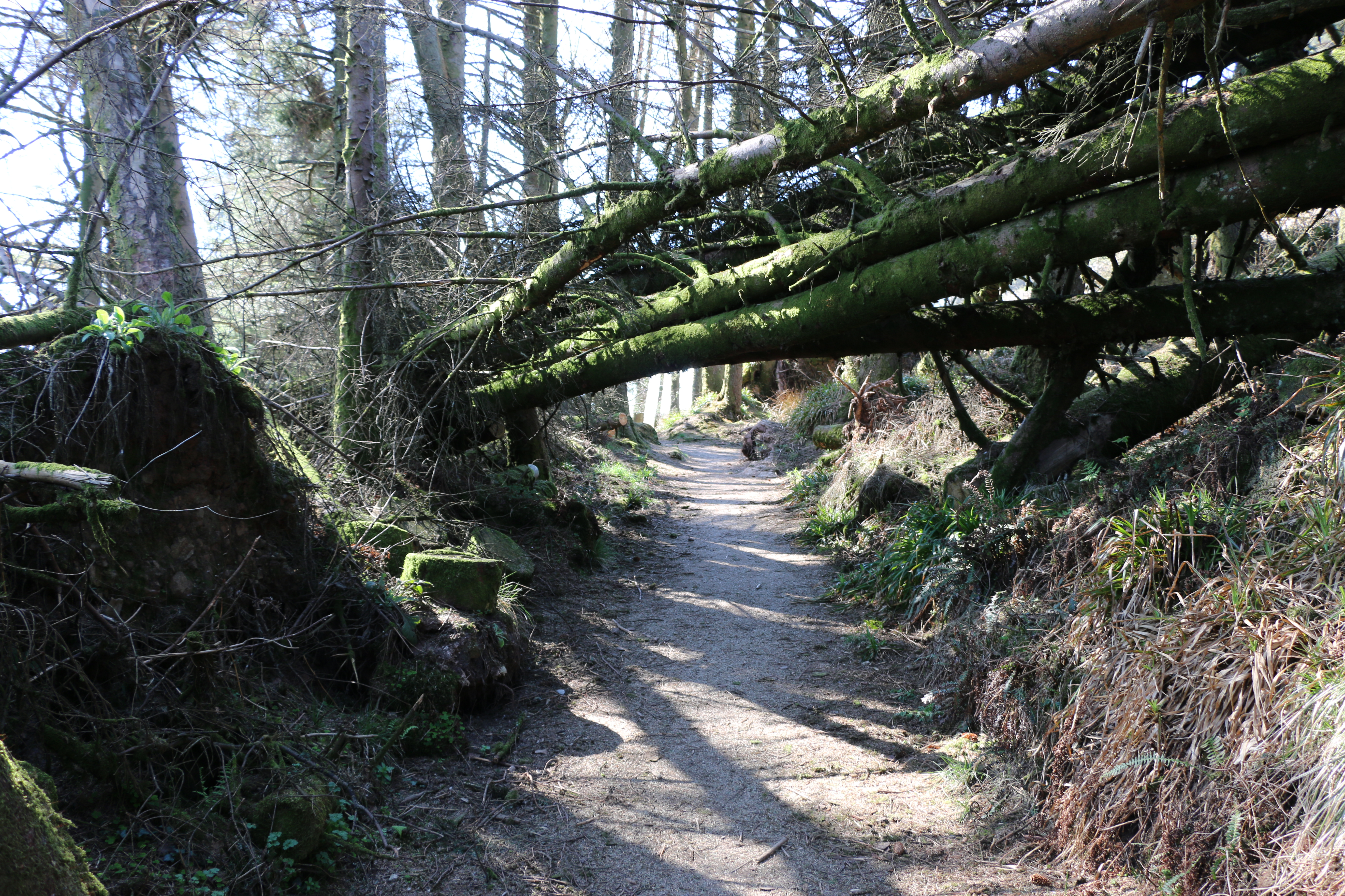
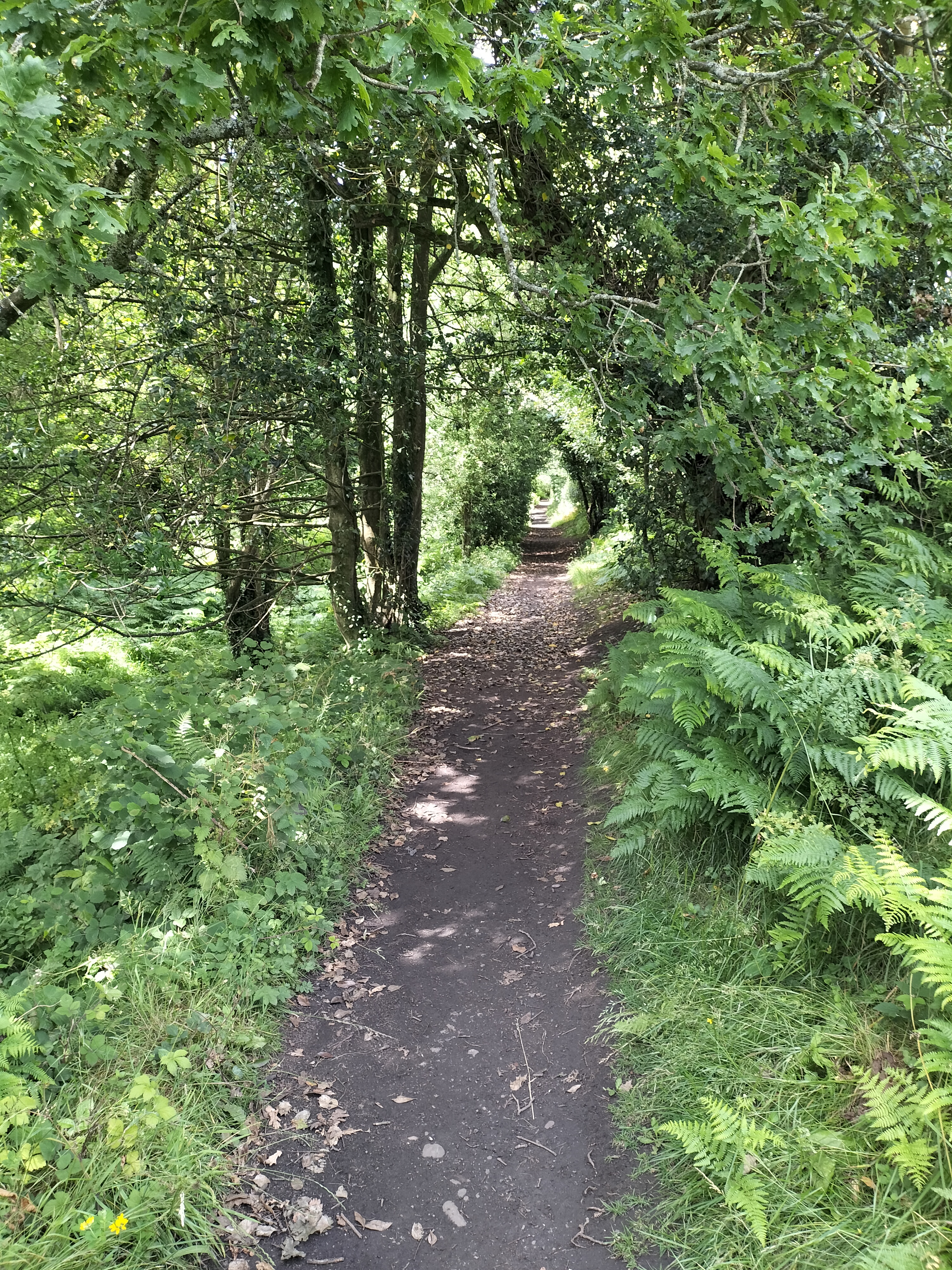
We duck under the trunks of a couple of trees that have fallen across the path. One has a plaque nailed to it – “Bow your heads for you enter sacred and magical lands”. As we were to discover when we finally reached Loch Garbad. But first to the Eas Mór falls.

Photo cortesy of https://tinyurl.com/msk5skns

Today the falls are not as magical as the photographs from the travel website promised when we discovered this walk. It’s a little disappointing but it’s because the weather has been so dry. Only a small slender stream of water runs, mostly obsured by the surrounding shrubs and grasses from where we stand. (hence the above borrowed photograph). It’s certainly not as impressive as the Glenashdale Waterfall from our first walk on Arran, but it does fall over the cliff in a single dramatic drop into a deep dark gorge.

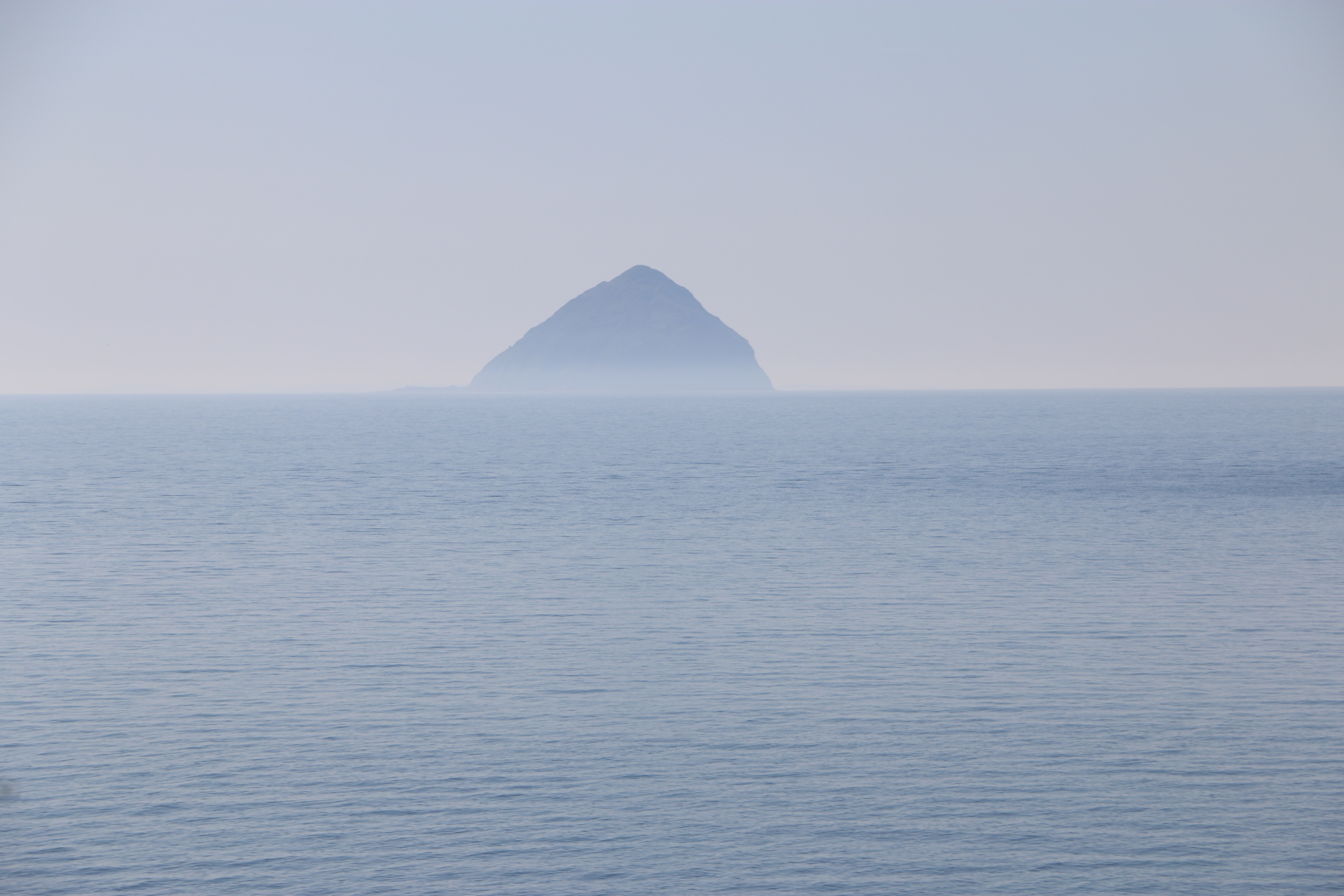
At a stone seat there’s a path junction with a signpost for Loch Garbad. From the description on the map we are following we expected to be walking though woodland but no; all the forest towards the loch has been felled under the Eas Mor project. This is the gradual conversion of the commercial conifer plantations back to semi-natural trees, so many of these have already been planted as saplings. (I’ve included the Facebook link above, because I think it is so impressive what they are doing in so many areas).This is a vast open area of brash (the above ground parts of the tree that hasn’t been removed from the site after felling – the foliage, branches and crown). Not yet as attractive as it will be, but it has opened up a terrific view across to Pladda Island to Ailsa Craig….

We stop for a while to admire and take photographs. Then carry on along the track …

It’s a bit of a slog. We meet only one other couple with a dog. Dusk and it exchange pleasantries, as do we, and then we plod on. (Yes, that is a sly photo of Dusk and me, taken by the Photographer!) The track is rough and narrow in places. I wonder how it must have felt in past times, winding through the overgrown woods, and I appreciate the openness, being able to see that last hill before we get to Loch Garbad.

Not far now.

We’re told to ‘pose’ – As you may be able to see, neither Dusk nor I appreciate this.

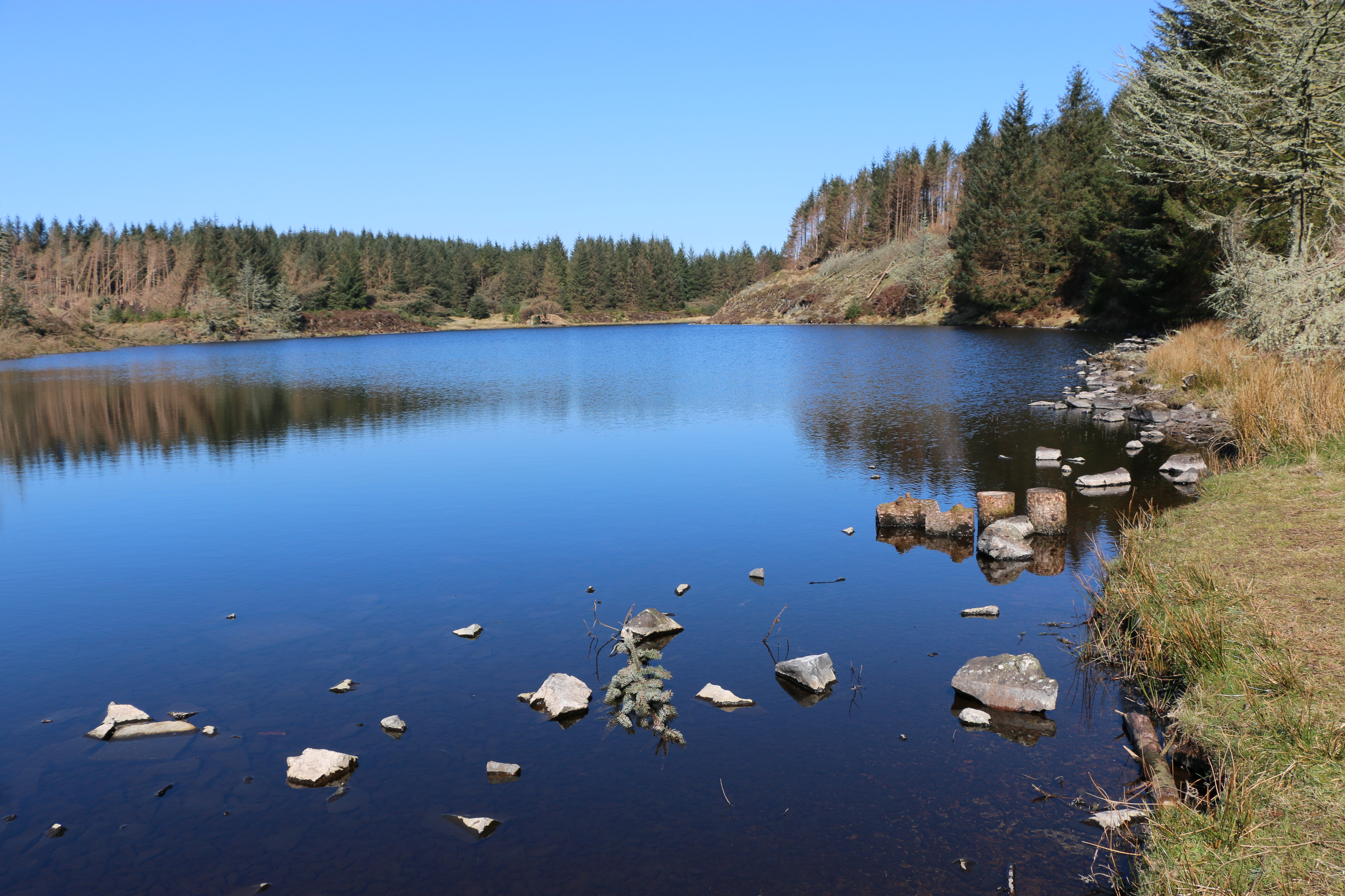
We’re both much happier sitting down for a welcome drink of water and taking in the remote beauty of the loch, whilst the Photographer goes off to do his own thing.

An hour later and we’re off again, somehow managing to take a wrong turn and having to retrace our steps to get onto the right path down the hill. Eventually taking the steps past the waterfall again and towards

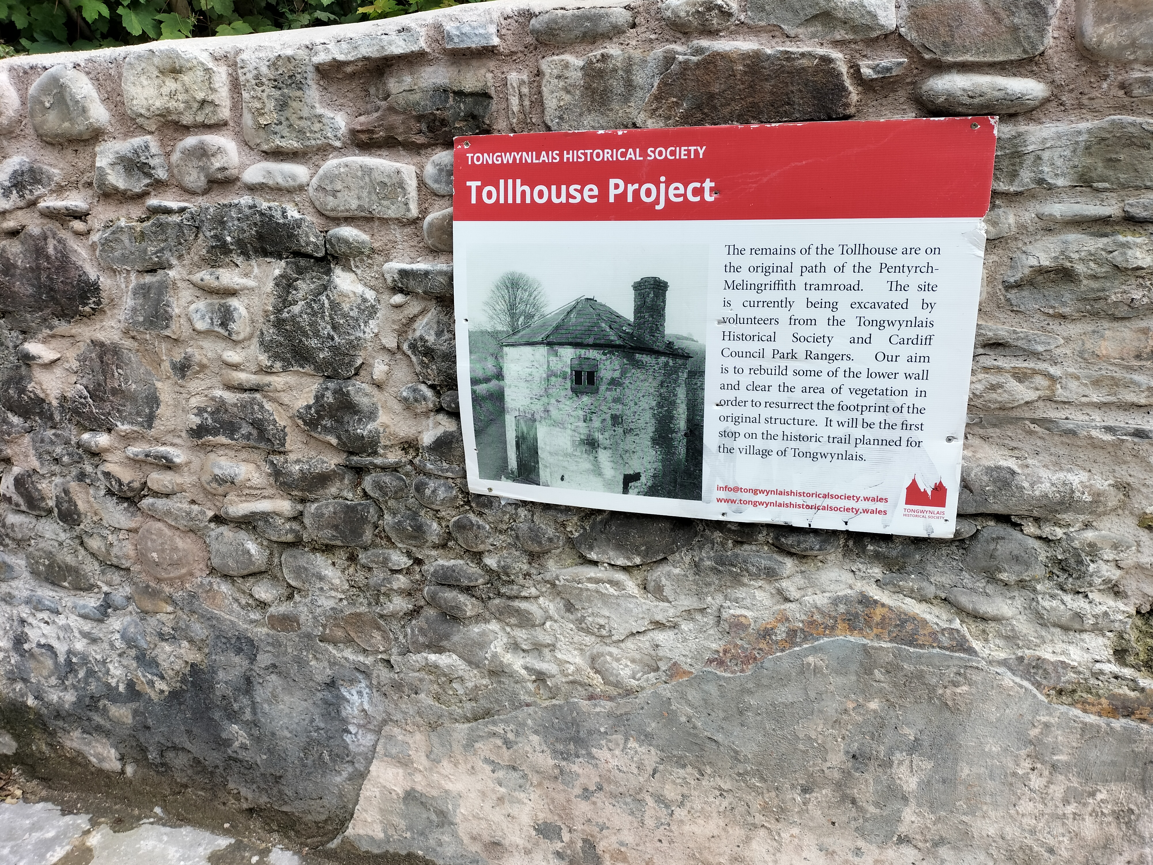
The Library in the Woods – which is exactly what it says – housed in a small log cabin it’s a hidden library in beautiful woodland, and filled with books and messages left by visitors over the years. Another project created by Eas Mor Ecology and built in 1998 from trees felled in a storm on Boxing Day.

Time to leave. We take a narrow path downwards through woods and across the bridge over the stream fed by the waterfall. Just in time … to see the cafe closing. “Never mind,” says the Photographer, ” We’ll be back at the house in no time. We can have a coffee there. What’s for tea?”

https://tinyurl.com/4y3ftdnw

Where We Walked – Glenashdale Waterfall and the Giant’s Graves, Arran, Scotland #Walks #Photographs #Viewpoints #Waterfalls #Legends #History

We’ve just returned from a wonderful couple of weeks on Arran. The photographer sourced the walks for us. Today he promises a short outing because it’s rather warm; “maybe a couple of hours allowing for stops… for Dusk, our borrowed border collie, of course”. (Oh, not for photographs then?).

We are going to one of the most famous waterfalls on Arran, Glenashdale Falls, and then on to see the Giants’ Graves.

We follow the directions from a rather old book of walks, which immediately adds a couple of miles on by sending us along a wide rather rough road, instead of going to the end of Whiting Bay and turning onto the forestry track.

Though I have to admit we passed some peaceful scenic views.

We were unable to follow the path through the forest to the Iron Fort due to the damage and fallen trees, caused by the latest storm on the island. So we continued along the wide track for another mile.

We reached Glenashdale Falls, also known as Eas a’ Chrannaig, one of a series of falls on the Glenashdale Burn, which flows from moorland near the summit of Tighvein eastwards towards Whiting Bay.

The viewing platform – not for anyone scared of heights

Not sure why I was encouraged to go along the viewing platform first. Thinking about it, my walking companions may have thought I was heavier than the two of them put together…

The sound of the rushing water competes with the breeze rustling through the trees around us. It’s a magnificent, awe inspiring place.

We retraced our steps from the waterfall and turned left, following a sign to the Giant’s Graves along the wide track … for another mile.

The Photographer trudges through tall grass to the edge of the cliff to take pictures. At one point he disappears completely. Dusk and I wait – patiently – he’s done this disappearing act many times in the past, just to get a good shot of somewhere.

When he returns we walk on, until a sign for a narrow path informs us we’re almost at the site of the Giants’ Graves.

The Giants’ Graves are the remains of two Neolithic chambered tombs on the Isle of Arran in Scotland on a ridge one hundred and twenty metres above the sea and overlooking Whiting Bay to the south. Mostly ruined, with turf covering part of the remains, they still have an air of mystery standing proud in a clearing in the forest.
The North cairn, excavated in 1902, has a chamber that is six metres long, and is around one metre wide. Among the artifacts recovered were pottery shards, flint knives, and leaf-shaped arrowheads.
The South Giant’s Grave has a chamber about four metres long, and over one metre wide. The initial excavations in 1902 only revealed soil and stones, but in 1961/2 more exploration produced nine shards of a round-based vessel, and fragments of burnt bone.

Legend has it that the giant referred to is Fionn mac Cumhaill, an early Irish war-leader, and his followers, known as the Fianna. Between the 10th and 14th centuries, his legend became widely known in Scotland. According to legend, Fionn and the Fianna had superhuman strength and size, being as much as 500 times larger than a man.

It’s getting late; we need to get back to Whiting Bay.

Beyond the graves the narrow path winds its way steeply down. And one of the rare times the Photographer catches me unawares for a photograph … from behind!

One last photo – Whiting Bay, with Holy Island in the distance.

The walk took us just a little more than the two hours that the more up-to-date directions we later discovered, so the following day we had a rest (using Dusk as our excuse again!) before our next adventure – a coastal trek as far as Kingscross Point, stopping to photograph the ruins of a viking fort and the views of Holy Island, before continuing back to Whiting Bay.

The Holy Island or Holy Isle is an island in the Firth of Clyde, off the west coast of central Scotland, inside Lamlash Bay on the larger Isle of Arran. The island is around three kilometres long and around one kilometre wide. Its highest point is the hill Mullach Mòr. There will be more about the Holy Island in our next post of walking on Arran.

And now a little self indulgent promotion…

A gripping ‘cuckoo in the nest’ domestic thriller

After the death of their mum, twins Chloe and Charlie are shocked when their dad introduces Lynne as their ‘new mummy’. Lynne, a district nurse, is trusted in the community, but the twins can see her kind smile doesn’t meet her eyes. In the months that follow they suffer the torment Lynne brings to their house as she stops at nothing in her need to be in control.

Betrayed, separated and alone, the twins struggle to build new lives as adults, but will they find happiness or repeat past mistakes? Will they discover Lynne’s secret plans for their father? Will they find each other in time?

The Stranger in My House is a gripping ‘cuckoo in the nest’ domestic thriller, exploring how coercive control can tear a family apart. Set in Yorkshire and Cardiff, from the 60s to the winter of discontent, The Stranger in My House dramatises both the cruelty and the love families hide behind closed doors.

“Judith Barrow’s greatest strength is her understanding of her characters and the times in which they live.” Terry Tyler

https://tinyurl.com/36m89w6t

Grateful for this reader’s review. One of the first for The Stranger in my House, when it was published in November 2024.

The Stranger in my House is an urgently compelling story of abusive power, detailing the damage that happens when those with the power to protect vulnerable children choose to turn their eyes away. Judith Barrow takes us into the dark & haunted world of coercive control, masterfully turning her own power as a storyteller on to this troubling theme, exploring it with insight & sensitivity.

In Lynne, the author has created a monster. Her victims, twin children Chloe & Charlie & their hapless father, are each portrayed with Judith Barrow’s usual precision & humanity; the writing as always, is impeccable.

It is a troubling book, but ultimately, on some level, redemptive. And although I found the ending satisfying & honest, I was nevertheless left with a sense of sadness, not only for Chloe & Charlie, but because decades on from the events in this book we still exist in a world where the emotional needs of children are too often subsumed by those of selfish, self-serving, abusive adults.
The Stranger in my House is a hugely important book & I highly recommend it.

https://tinyurl.com/36m89w6t

Where We Walked @Moel Hebog @Beddgelert @North Wales #walks #photographs #holidays

Moel Hebog (Welsh for Bare Hill of the Hawk) is a mountain in Snowdonia, which dominates the view west from the village of Beddgelert.

This was the next walk we did. I say ‘walk’ as a vague description. And I need to say at this point that we hadn’t read the following review beforehand.

“This is very much a steepish persistent trek from the beginning to the end. The path is very sketchy in places and you have to work out the best way forward. You go around the false peak and a bit further up you come to a near vertical wall bit. Be careful here as a number of false paths on where to go up. Take your time to work out the safe route which is on the left side of the paths. It’s only two-four steps scramble then you are back on a reasonably marked trekking path. This trek is not for beginners you really need the experience of being able to work out safe routes and a little scrambling experience. You also need a reasonable level of fitness as it’s very much a full on upwards & downwards trek, not any flattish areas. When I did it mid May 2024 the forest walk on the descent was impassable as flooded, very boggy so had to walk around the gravel tracks that added around 4 miles to the trek. Really enjoyed this trek, it is physically challenging as you gain height quickly, I would fully recommend trekking poles as they help. The downward grassier slope going down to the forest is steep so trekking poles really useful. Enjoy, take your time and stay safe.”

Oblivious to this review (but with our trusty walking poles, as usual), we walked past Beddgelert Railway Station, then along a lane crossing the railway line.

We passed a farm, said hello to the dog who came out to watch us, and walked through a small wood before the land opened up. There was a stone path across crossing a field, and then a post which indicated we needed to go straight ahead to a stile over the stone wall. (Yes, there had to be a stile!!)

At first the path was a meandering course on spiky grass with golden brown ferns set in a landscape of small outcrops and boulders. (Later in the day, having coffee in a small cafe, we met three young climbers who told us that these boulders were called erratics, glacial boulders or rocks that have been transported by ice and deposited. The type of rock – the lithology – the physical, chemical, and mineralogical properties – that the glacial boulder is made from is different to that of the bedrock where it’s been deposited.) We live and learn!

As we climbed,I took advantage of every photo stop, as usual. (my ‘catching my breath’ time). The landscape was glorious. And there, in the distance, was Llyn Dinas.

We stopped for lunch, debating at this point on whether we’d gone as far as we should (could!) Just then two couples passed, going back down. ” That’s us done,” said one of the men. “We know when we’re beaten. Off for a pint.” They were about twenty years younger than us. We looked at one another, made our decision; if going any further was too much for them, we had no chance. We packed up our things.

So there we are – sometimes ignorance is bliss. Or very foolish. But it was a lovely day, we took our time, had food and water – and knew when we’d got as far as we wanted to.

We took one last look at the dark peak of SnowdonIn in the far distance before we turned and made our way down towards the road.Got some fabulous shots though,” said the photographer, cheerfully. I agreed, relieved to be back on tarmac.

Later, looking back at the walk, I read the following.’The Moel Hebog shield (Welsh: Tarian Moel Hebog) or the Moel Siabod shield, is a large copper-alloy shield from Bronze Age, found in a bog on he north-west slopes of Moel Hebog. Discovered in 1784, it dates from 1300–1000 BC and is now in the British Museum in London.

Richard Blurton (a specialist in South Asian art and archaeology, formerly Assistant Keeper at the British Museum), wrote about the shield in his book The Enduring Image: Treasures from the British Museum (only £209, plus £9.75 postage). He says, “This shield is a splendid example, representative of the rise of large sheet-bronze work in later Bronze Age Europe. Much effort was directed towards the production of ceremonial metal armour indicating the prevalence of the idea of man as a warrior.

Just thought I’d share that!

Where We Walked @Dinas Lake @LynDinas @Beddgelert @North Wales #walks #photographs #holidays #MondayBlogs

Llyn Dinas is a fairly shallow lake that lies on the valley floor a few miles north of Beddgelert in Gwynedd in north Wales. It is formed by the River Glaslyn. The lake takes its name from the nearby Dinas Emrys, a hill just downstream of the lake where a rock, Carreg yr Eryr (The stone of the eagle), was said ,in a charter of 1198 ,to mark the spot where the boundaries of the three medieval Welsh land division of Aberconwy, Ardudwy and Arfon met. According to Giraldus Cambrensis an eagle used to perch on it once a week, anticipating battle between the men of the three cantrefs.

We walked around Dinas Lake twice. Well, I say that. I should say we attempted to walk around the lake twice.

After that glorious, long day’s walk to Beddgelert, the clouds the following morning promised rain, and it was cold. Not to be thwarted we rugged up and set off.

On that first walk around Dinas Lake, we were attempting the one the National Trust recommended in the brochure we found in the cottage. We later discovered it was 1998 version, so unfortunately, the directions were out of date. Halfway up the hill it petered out into brambles and undergrowth.

This actually turned out to be fortunate. Giving up on the idea of cutting our way through the brambles – mainly because we didn’t have secateurs or knives, we backtracked and decide to walk to the end of the lake. Within ten minutes, we had hailstones bouncing down on us and we needed to shelter close to the stone wall under trees, alongside nine sheep who seemed completely oblivious to us. We gave up and went back to the cottage.

The next day, with the weather just about fine, we decided to try Lake Dinas again.

The water was calm, there was a party of canoeists preparing to go on the lake, and on the far side a group of children were being taken up a fast running stream. Dressed in hard hats and waterproofs it looked as if they were participating in a form of orienteering. From the screams of laughter we presumed they were enjoying themselves. Not for us we decided.

We crossed the bridge over the river to the path just as the rain started.

The path is banked by many rowan trees. There was a plethora of berries on them all. Is that a sign of a bad winter to come? Or is that an old wives tale? (as soon as I wrote “old wives’ tale” I wondered why it was called that. Apparently the name “old wives’ tale” comes from the fact that older women would often pass down their advice to the younger generation in the form of sayings that were easy to remember. The “wives” don’t refer only to married women, though. The term came from the Old English word wif, which means “woman.”) Just another rabbit hole I went down!!

At the far end of the lake we saw a farm house with outbuildings. There seemed to be a lot of activity. Despite the rain and being naturally nosy I urged the Photographer on with the words, ” I bet there’ll be a great view looking back along the lake.” It worked!!

This is the farm… Llyndy Isaf, a farm in Eryri (Snowdon) owned by the National Trust, since 2012 (Image: National Trust)

The farm was bought following a public fundraising campaign to preserve it for the nation. It has previously been home to five young farmers on a scholarship, who have managed Welsh Mountain ewes and Welsh Black cattle on the stunning site, which includes several Sites of Scientific Special Interest (SSSI:

Lake Dinas’ geology is important for nature conservation with habitats of saltmarsh, rush pasture, mire, mudflats, and reedbed, so is a natural home to a variety of wildlife, including bird species, such as Red Kites, Pied Flycatchers, Redstarts, Common Sandpipers, Dippers and Grey Wagtails, (a bird twitcher’s dream), over two hundred invertebrate species, and more many species of lichens and mosses, liverworts and hornworts ( bryophytes – non-vascular plants, which have no roots or vascular tissue, so absorb water and nutrients from the air through their surfaces).

When we approached the Llyndy Isaf farmhouse we were told it was a production team for television. They were more than willing to explain what they were working on.The National Trust has been on the hunt for someone to take over Llyndy Isaf farm. The process of choosing a tenant will be documented for Channel 4’s Our Dream Farm with Matt Baker, in early 2025. Applicants are vying for a fifteen year tenancy of the farm by participating in a three-week selection process. The Trust is seeking an individual with a fervour for sustainable farming.

A drone flew overhead filming Matt Baker with the lake in the background at the same time as the Photographer was attempting to take his photograph at the end of the lake. I’m just hoping the drone didn’t capture the two bedraggled people peering over the wall. I guess, when the programme is aired, we’ll see…

Where We Walked: Copper Mine @Cwm Bychan valley in @Snowdoni National Park near @Beddgelert @North Wales #walks #photographs #holidays

The second day, we knew we needed to take it easy, so we planned a short walk for the afternoon. Around three miles from the cottage that we were staying in was the disused Cwm Bychan copper mine, so we decided to explore.


The start of the walk was from the Nantmor National Trust car park, easy enough to find. We went under the railway bridge (still no steam train), and onto the stony path that led up through woods.

We’d been told these were bluebell woods, but, of course, in September no signs of bluebells, but impressive heather anyway.The area also includes internationally rare heathland, found only in the western coastal areas of Europe that provides habitat for numerous butterflies and birds.

The path wound upwards, sometimes not as distinguishable, always following the stream.

We were tempted to sit here, but I knew if I sat down I might not stand up again; the short walk had turned into yet another climb – and the weather looked as though it was changing.

But, gradually the woodland path changed into easier, wider paths on the open mountain, and I was reliably informed that the remains of the copper mines was, “just around the corner”.


And there it was!

Various relics of that era can still be seen, including the aerial ropeway with its pylons and terminal wheel. And, in the background, the slag heaps of waste copper.

The evidence of the copper mining that used to be carried out here is quite poignant. The silence, broken only by occasional bird calls, the rustle of the breeze through the long grass, the bubbling of the stream, obviously a contrast to how things used to be.

Mining has been dated back to at least the seventeenth century in Cwm Bychan. The mines finally closed in the nineteenth century, then re-opened in the nineteen twenties. It was at this time that an aerial ropeway was built to help remove the Chalcopyrite ore for processing. But the attempt to restart production was short lived and the mine finally closed by the end of that decade.

I needed to research what Chalcopyrite is – a copper-iron sulphide mineral, the primary source of copper metal.

Image courtesy of Wikipedia

I learned that Chalcopyrite, also called Peacock Ore is thought to be an uplifting stone. It may ground nervous energy which allows the body and mind to let go of stress and embrace calm. It also may be used to remove energy blockages, cleansing, activating and aligning the chakras and energy bodies at the same time. To be an excellent aid to increase self-esteem, banish fears and doubts, and soothe the emotions. … fascinating. They must have known this in the nineteen twenties?

.

.

Where We Walked #Nantmor to #Beddgelert via Bryn Ddu – the Fisherman’s Path -River Glaslyn #Wales #walks #climbs #photographs #no stiles #holidays. Part Three – the Last Leg of the Walk

The last part of our hike walk was along the Fisherman’s Walk,following the course of the Afon Glaslyn, a sixteen mile sea trout river whose source is a lake in a valley on the edge of Snowdon,and eventually runs into Tremadog Bay near Porthmadog.

We’d rewarded ourselves with a fabulously tasty but light meal in a bistro in Beddgelert and a wander around for an hour or so, before tackling the last part of the walk. After refilling our water bottles we strolled along a paved footpath along the riverside. This will be a doddle, I thought, watching the Photographer indulge in a few photos shots. A nice, calm, wide river.

Further on we crossed a footbridge beside the railway bridge and went through two kissing gates that crossed the railway line (still no sign of the elusive steam engine – to his disappointment and my relief at that point – after the day we’d had I didn’t fancy being run over by a steam train!).

But I wasn’t prepared for what was around the corner…

Glorious though the river was, it had rained quite a lot in the previous few weeks. Now Afon Glaslyn flowed swiftly over rocks and gulleys. And the path is made up of slabs, rocks and, sometimes an indiscernible way forward. I think the only thing I said in the next hour was … “Where’s the path gone?”

See what I mean?

This section was especially challenging – note the handholds hammered into the rock face so we could swing around the corner of the rock on the narrow path … er … stone slabs above the churning Afon Glaslyn.

One last scramble over rocks before we reached the relatively safer gravel path

And back onto the bridge that we’d stood on at the beginning of the day. And a chance for a last photograph.

And … a welcome sight … back to the cosy farm cottage in Nantmor, where we were staying for the week. Ready for an evening of quiet editing of my next book – The Stranger in my House

Nantmor is famous for being the filming location of the 1958 film, Inn of the Sixth Happiness starring Ingrid Bergman and Robert Donat. The film was based on the true story of Gladys Aylward,a British nurse who became a missionary in China in the unsettled years leading up to the Second World War. Nantmor doubled as China and people from the Chinese communities in Liverpool were brought in as extras for filming.

I found an interesting article on the history and repairs of the Popular Fisherman’s path in Beddgelert when ” After winter storms and high river levels washed away a 100m section of the Fisherman’s path, the Welsh Highland Railway swapped its cargo of tourists for stone, reverting to its original purpose for a day. Repaired, thanks to special delivery by Welsh Highland Railway.” Published: 20 February 2023: https://tinyurl.com/32md9b3f

Where We Walked #Nantmor to Beddgelert via Bryn Ddu #Wales #walks #climbs #photographs #holidays – Part Two

Continuing our walk …

From the lookout point we could see Beddgelert – now only two miles away. All down hill. Very downhill!

The village is in the Snowdonia area of Gwynedd, Wales. It’s thought that it’s possibly named after an early Christian missionary called Cilert who settled there to become the leader in the eigth century. The earliest record of the name Beddgelert appears on a document dated 1258( recorded as Bekelert). The local Welsh dialect often shortens the name of the village to Begél.

It didn’t look very much closer through binoculars, to be honest.

Image courtesy of https://en.wikipedia.org/wiki/Welsh_Highland_Railway

Zig-zagging down the steep hillside to reach Beddgelert, and then through the magnificent Aberglaslyn Pass and on to Porthmadog, is the Welsh Highland Railway, the UK’s longest heritage railway. These trains are the world’s most powerful narrow gauge steam locomotives, and run for twenty-five miles from Caernarfon to Porthmadog. They climb from sea level to over six hundred and fifty feet below Snowdon, before descending to Beddgelert. On numerous walks we heard the ‘toot-toot’ of the train. Many times we waited for it to come into view … until we realised the sound echoed all around the mountains … and it was always miles away from where we eagerly anticipated (well, one of us did!) a “great photo opportunity”.

One of the most sought after/ looked for attraction – from a tourist point of view – is the raised mound in the village, called “Gelert’s Grave” and the statue of the faithful hound. The folk tale is synonymous with Beddgelert. By the way, the ‘hill’ (as the photographer first described it to me) in the background is Bryn Ddu mountain – the one we’d just scambled down.

But the grave was actually built by the late 18th-century landlord of the Goat Hotel, David Pritchard, who created it in order to encourage tourism.

We called in to have a wander around the local church, the Church of St. Mary stands at the end of Stryd yr Eglwys (Church Street). Parts of the building date from the 12th century; the chapel section being originally a part of an Augustinian Monastery. the rest the of the monastery was destroyed by fire during Edward I’s war of conquest. It really is a lovely peaceful church. And welcoming, as the following shows …

The village is also linked with the Rupert Bear stories.

Image courtesy of https://www.beddgelerttourism.com/Rupert/

Alfred Bestall wrote and illustrated some of the stories whilst he lived in the village, in a cottage at the foot of the Mynydd Sygun ( Sygun Mountain). There is even a small area known as ‘Rupert Garden’ in the village, dedicated to the Bear; a short walk from Alfred Bestall’s old home.

Lying in the heart of Snowdonia, Beddgelert is small, and a beautiful conservation village in the heart of the National Park, nestled below mountains at the confluence of the Glaslyn and Colwyn rivers. The path alongside the Glaslyn river was the last section of our walk back to Nantmoor. The path sounds so innocuous doesn’t it? Especially when it’s called the Fisherman’s Path – images of quiet contemplation, the swish of fishing rods, the ripple of water…

On to Part Three…

Where We Walked #Nantmor to Beddgelert via Bryn Ddu #Wales #walks #climbs #photographs #nostiles #holidays – Part One

‘It’s the longest walk we’ll do,’ said the Photographer, ‘But it’s such a glorious day, and we’ll get some gorgeous views. Better take the walking poles as well.’

I know. I know… ‘walking poles’ should have been the clue!

It was a gentle, if somewhat a rocky start to the walk through the woods.

And then the Afon Glaslyn (Glaslyn River) came into view. ‘We come back to here along the river bank,’ the Photographer said.

‘Oh, lovely, said I!’ And meant it… then

We went through the kissing gate, over the road bridge, turned left on the road, until we saw a National Trust sign for Coed Aberglaslyn (Aberglaslyn Trees) and followed the footpath towards the stream.

So far so good. “Follow the waymarkers up through the woods”. But the waymarkers had long since disappeared. And here I need to say, the following was completely my fault. “Follow the path to the stream”, the directions read. So I did. But you would think, after all these years, the Photographer would know I have no sense of direction.

And here is the stream.

“Turn right,” the directions read. Across the stream? Which was flowing fast and deep. We read, and re-read the directions. We searched for a path.

For half an hour.

Suddenly we were joined by a couple. ‘We have the O.S.map on our mobiles,’ the man announced. ‘We know the way. You can follow us.’

So we did…

For almost an hour we followed them, clambering over boulders, up along boggy paths (sheep trails, they turned out to be), splashed through water, until we reached the top of the hill. To discover it wasn’t the top of the hill. Whereupon the woman turned to us and cheerfully said, ‘We’re not very good at orienteering. I think we’ve gone wrong.’

We went our separate ways. We slipped, negotiated the boulders, slithered through mud, back to the stream. And then back to the bridge. And there we found a waymarker – hanging off a post, pointing to the ground. We looked aroundand there, going up through the wood were long narrow indents in the ground… steps!! Of a sort.

It says in the directions there should be a stile at the top. Chance it?’ the Photographer asked. ‘Or would you rather give up?’

A stile!! But his words sounded suspiciously like a challenge. I’ve never been able to resist a challenge…

We tackled the way up the hill, winding through the trees. It turned out there were just over a hundred of the so-called steps, which necessitated hanging onto trees and hauling ourselves up branch by branch or hauling one another up in places. We had lots of stops for breath. And we needed those walking poles.

Until we were actually on Bryn Ddu. The halfway point to Beddgelert. Finally we were on the right track.

We stopped for a few photographs.

Before setting off again to search out the base of a tower, built on a prominent outcrop at a viewpoint overlooking Aberglaslyn Pass. The whole structure is built on a stone plinth which forms a narrow terrace around the tower. Thought to be a wartime lookout post.

From the lookout point we could see Beddgelert … in the distance. And the narrow trail winding its way down the hill. We stopped for much needed refreshments, and to catch our breath before tackling the next half of the walk.

To be continued…

Where We Walked – @Janet’s Foss #Walks #Photographs @Yorkshire Dales #MondayBlog

Our last walk in the Yorkshire Dales was a short early evening stroll to a small waterfall called Janet’s Foss, just outside Malham. The name for the waterfall apparently comes from an old folktale that a fairy queen, Janet (sometimes Jennet), lives in a cave at the rear of the fall. There are numerous stories about this: usually wraiths are not thought to be ghosts or demons, but rather a strange entity somewhere in between the two, similar to poltergeists but much more powerful when appearing as a full-bodied apparition. With Janet, there are claims that she would have practised black magic in life and this eternal damnation is her punishment. So, from the numerous conflicting tales we were told when we asked, she was either a magical fairy, or a vengeful creature.

The waterfall carries Gordale Beck over a limestone outcrop into a deep pool below. The pool was traditionally used for sheep dipping, which drew in local villagers as a social occasion. We were told that there have also been a few wedding ceremonies there. Our resident font of all knowledge in the local pub told us that the pool is occasionally used by all-weather wild swimmers. When I mentioned this to the photographer he announced he hadn’t brought his swimming trunks. Not sure he had the right idea about ‘wild swimming’.

Image courtesy of Annabelle Bradley

The footpath from Malham starts from Malham Smithy, where the female blacksmith, Annabelle Bradley, runs blacksmith experience days, and also designs and hand forges sculptural and functional wrought ironwork. We’d stopped to watch her work from outside the door, earlier in the week. It was fascinating. Just leaving the link here, just in case you’re interested: https://www.malhamsmithyonline.co.uk/

Walking over a short bridge and alongside a small beck we went through fields and kissing gates. (No stiles!!)

On the footpath to Janet’s Foss a couple of old tree stumps have become home to hundreds of pennies where people have left them and made a wish to Janet.

We could smell the garlic even before we entered the wood.

Here I go again … can anyone else see the profile of a face in these rocks?

We stayed listening to the rhythmic flow of the water, and waiting for the mysterious green mist that was supposed to sometimes rise from the water- until the chattering and clattering of boots announced the arrival of walkers, and brought us back to reality.

Time to make our way back to the cottage we were staying in. Time to pack for our return home the following morning. Time for just one more glass of wine.

Where We Walked – @VictoriaCave @YorkshireDales #Walks #Photographs @Yorkshire Dales #MondayBlog

Remember me saying in the last post about our visit to Catrigg Force – a small but impressive waterfall just east of the village of Stainforth? And that the first time we found it we’d actually planned to call to see it as the first part of a massively, more strenuous, longer walk – a longer walk, planned by the photographer? One where we could take in the landscape from the Victoria Cave in Ribblesdale? And I said, more to come on that another time? Well, this is it. The above is the last (nearly last) part of the track up to the cave

Another of my photographs when I stopped to take a breath on the path (path?!!) on the way up to the cave. The photographer was already there. Give him his due, he did come back to help me to the top.

And here it it, the limestone Victoria Cave, located east of Langcliffe in Ribblesdale and discovered by chance in 1837, the year of Queen Victoria’s coronation.

Until then the cave was unknown. Tinsmith Michael Horner (1813-1878) struggled through a small hole between rocks,searching for his dog and found the cave. Inside tound bones, coins and various metal objects on the sediment floor. Later, on the 28th June 1838, Joseph Jackson, a keen amateur archaeologist, investigated further. The Victorians were fascinated by ‘bone caves’ where there might be a possibility of finding evidence for the earliest humans and extinct animals. Some animal bones were actually found here. It’s thought that hyenas used the cave as a den and dragged bones that had been scavenged into it, including hippos, narrow-nosed rhino, elephants and spotted hyenas bones. After the last Ice Age the cave was used by hibernating brown bears. In amongst the animal bones of reindeer was an 11,000 year old antler harpoon point, the first evidence for people in the Yorkshire Dales. Some items from the cave are held at the Craven Museum in Skipton.

The roof of the cave has become increasingly unstable over the years and roof falls are possible. We didn’t go in!

This is another one of my photos (yes I do know it’s less inspiring than the photographer’s). But I spotted this from up high, from outside the cave – and thought it was a large teddy bear, or the skeleton of a teddy bear!! Of course, when we got closer… it was just a pile of rocks. Note to self – contact optician

Just before we set off on the downward trail, and with an eye on the clouds bubbling up in the distance, a photograph of the next five miles we needed to go.

And it’s here I will reveal a moment of a basic and elementary photographer’s mistake.

” One last photo before the rain sets in,” he says, scanning the vista. “I didn’t realise it had become so dark so quickly.”

I waited, didn’t say a word while he huffed and puffed, and glared at the sky. For quite a while Then I stated the obvious. ” Your lens cap is still on.”

Good job he has a brilliant sense of humour!!

We followed the trail past the rugged terrain of the Warrendale Knotts before descending the hillside on the way back to Settle.

Where we had a well- earned cup of tea and a scone.

Walking the Taff Trail – Well a small section of it anyway. And more of a stroll than a walk. #walks #cycling #photos #ThursdayThrowback #memories #history

An update to my post: Tongwynlais: Historic tollhouse given new lease of life:https://www.bbc.co.uk/news/uk-wales-62718289

Edmundo Ferreira-Rocha, of Cardiff council’s Urban Park Rangers, and councillor Linda Morgan cut the ribbon at the opening ceremony. © Tongwynlais Historical Society.

© Tongwynlais Historical Society.

Villagers have restored the shell of a historic “unloved eyesore” tollhouse demolished more than 70 years ago. The original building was among hundreds used to collect money from 18th and 19th century travellers. Volunteers in Tongwynlais, on the edge of Cardiff, have spent more than a year rebuilding it as the first step towards creating a local history trail. “Our volunteers have been fantastic,” said Sarah Barnes, of the Tongwynlais Historical Society.

*******************************************************************************************************

Before this wonderful restoration granddaughter and I walked the Taff Trailso thought you might like to see the before and after. Or, in the case of this blog, the “after and before”.

Put a lovely sunny day, with a dog desperate to go a walk, with a granddaughter who needs to be dragged from her mobile and bribed by the thought of a chocolate brownie and a drink of Sprite, and there was only one place to head for, the cafe in the garden centre at the end of the Taff Trail in Radyr.

The Radyr section of this lovely river walk is one we’ve done often

But this time we decided to meander along various smaller paths, even though we needed to retrace our steps numerous times. I was so glad we did because look what we found:

The tollhouse, once used by the Pentyrch and Melingriffith Iron and Tinplate Works in the late 1800s

Thanks to the Tongwynlais Historical Society ( co-founders,Sarah Barnes and Rob Wiseman) the Tollhouse returns to life. What was once nothing more than a few visible bricks covered in 70 years of vegetation, is now a recognisable shell complete with growing wildflower garden

I thought I’d better seek permission to add some of the photographs from the Tongwynlais Historical Society. I made contact with a very helpful chap, Jack Davies, whose fascinating website also contains an article about the Tollhouse and other history of the village: https://tongwynlais.com/history/

Granddaughter, Seren, with soulful companion, Benji, who patiently waited to continue his walk.

Seren also very kindly leant a hand to point out this lovely heart shaped stone, with a wonderful inscription:

Which immediately brought to mind (well, my mind anyway), my book, The Heart Stone, which was published by Honno, in 2021: So, never one to pass up on an opportunity…

The inspiration for The Heart Stone partly came from research for my degree on The First World War some years ago; a subject that both fascinates and repulses me. At the time I’d found my grandfather’s army records and discovered he’d volunteered to join the local Pals Battalion with two of his friends, although they were all underage.

I only ever remember him as a small man who spent his days in a single bed under the window in the parlour, who coughed a lot, and was very grumpy. He died when I was eight.

There was no conscription at the beginning of the war. The Pals Battalions were formed, to answer Lord Kitchener’s call for volunteers, by encouraging local magistrates to drum up community spirit and patriotic fervour.

 The gist of the speeches used were that young men,”…  should form a battalion of pals, a battalion in which friends will fight shoulder to shoulder for the honour of Britain and the credit of their town and villages.”

 My grandfather was gassed in 1916 near the Somme. He was also shell-shocked and was unemployed for the rest of his life. Once, my mother told me he had never spoken of his experience but had suffered nightmares for as long as she could remember. And that there were whole streets around the house where they’d lived where the men had never returned.

It’s a haunting image.

Four years ago, after my mother passed away and we were clearing her home, I found my grandfather’s army papers again.

 During the following week, whilst my husband and I were walking along the Pembrokeshire coastal path, we found a smooth stone, almost heart shaped, placed on top of a cairn amongst the Marram grass. Picking up the stone to examine it, a folded paper blew from underneath. There had been words on it but were, by then, indecipherable.

 A love note, I thought; a love note under a heart shaped stone.

 A love note, under a heart shaped stone, from a young man who had never returned.

 And so The Heart Stone started to form.

The Heart Stone was published by Honno Press in Feb 2021

And a Review of The Heart Stone:

https://amzn.to/3bCkx8w

And a buying link:

Amazon.co.uk: https://amzn.to/3hupbc1

Also available from Honno

And a little bit about me:

I’m,originally from Saddleworth, a group of villages on the edge of the Pennines, but have lived in Pembrokeshire, Wales, for over forty years.

I have an MA in Creative Writing with the University of Wales Trinity St David’s College, Carmarthen. BA (Hons) in Literature with the Open University, a Diploma in Drama from Swansea University. I’m also is a Creative Writing tutor and hold workshops on all genres.

And here I am:

https://twitter.com/judithbarrow77
https://www.facebook.com/judith.barrow.